Sarutal Trek

kailash-mansarova03
previous arrow
next arrow

Sarutal Trek

Region

Uttarakhand

Duration

6 Days, 5 Nights

Difficulty

Moderate to Difficult

Altitude

13,780 ft

Distance

38 Km

Trek Price: ₹16,999

Add-ons

Items Price (₹) Items Price (₹)
River Rafting (with Safety Kayaker) 1500 Bungee Jumping 2500
Offloading (Backpack) 1600 Single Occupancy Tent 1600
Trekking Shoes Rental 550 Down Jacket Rental 550
Trekking Pole Rental 250 Poncho / Rain Cover 200
Gloves 200 Thermal Water Bottle 300
Insurance 100 / day

Overview

Sarutal Trek – Overview

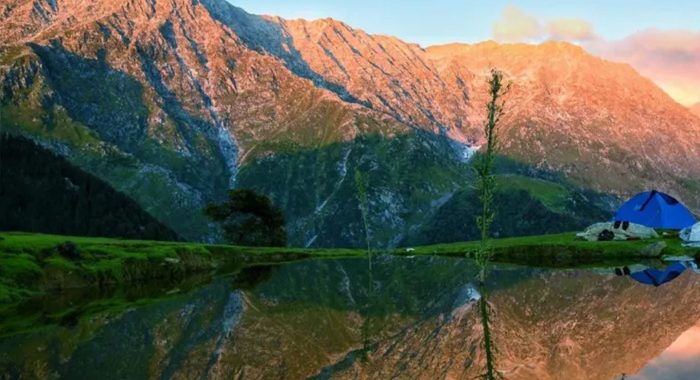
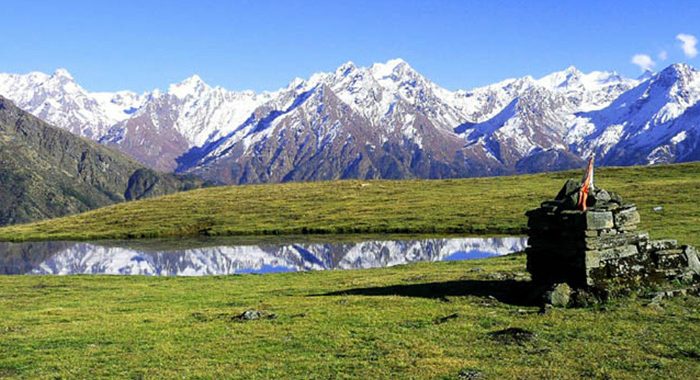
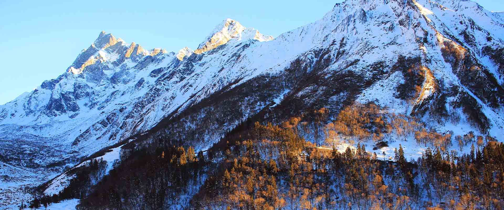
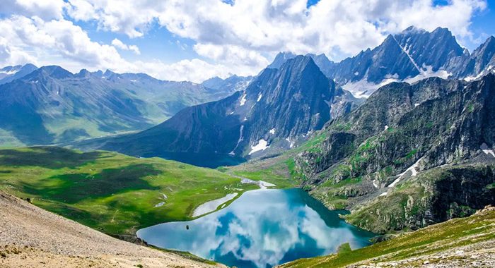
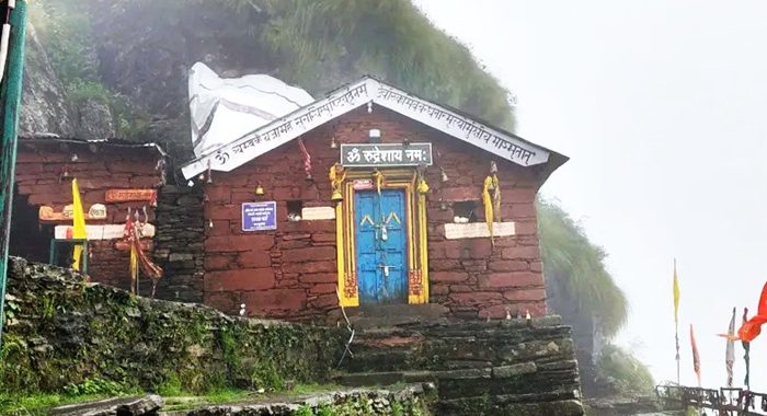
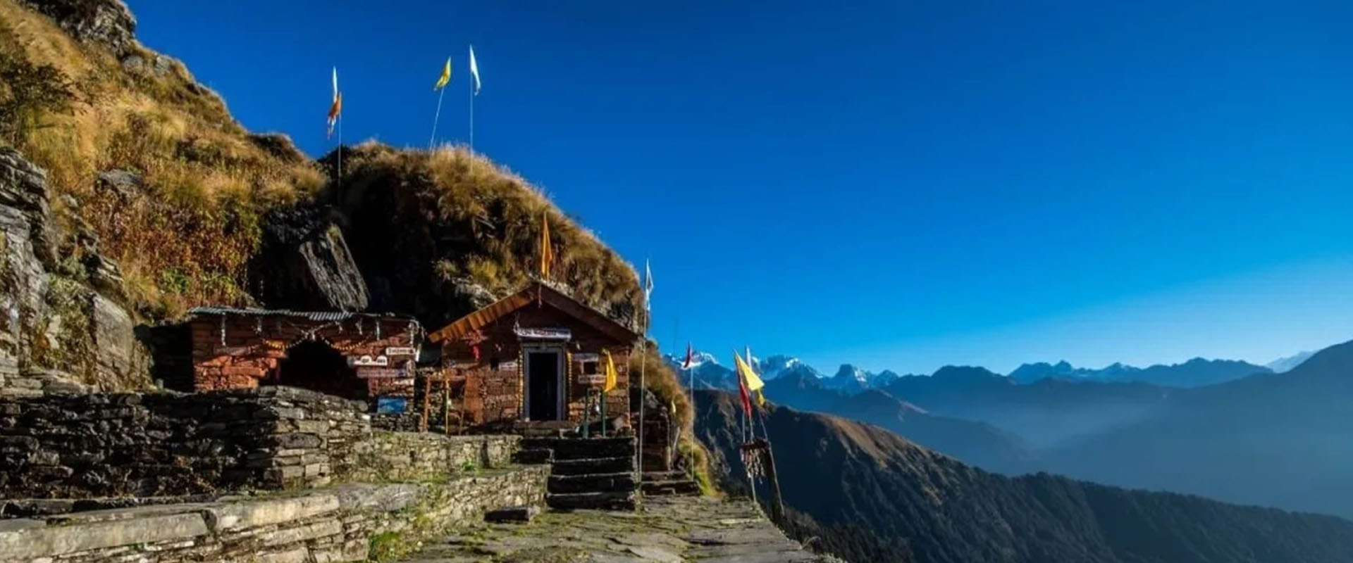
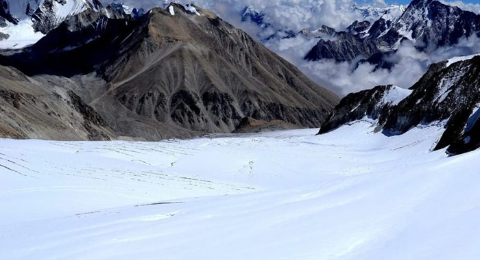
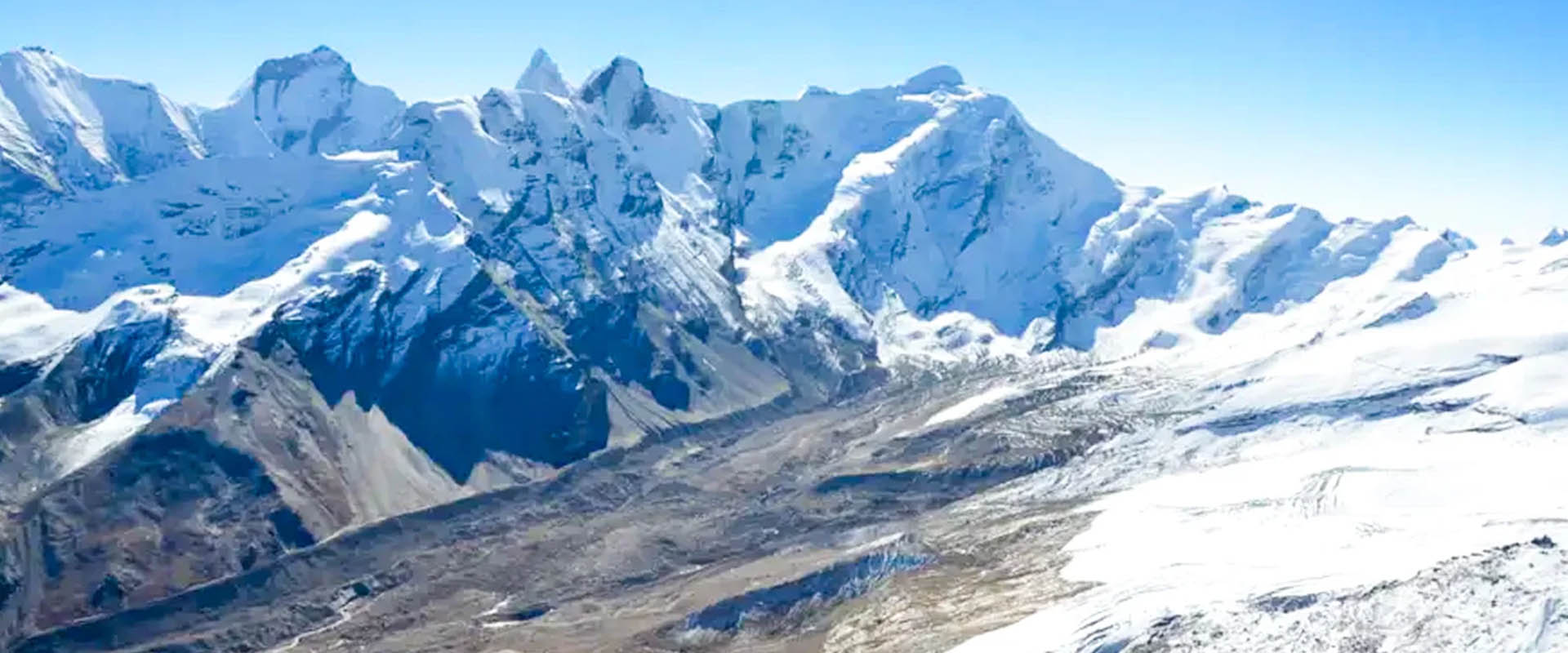
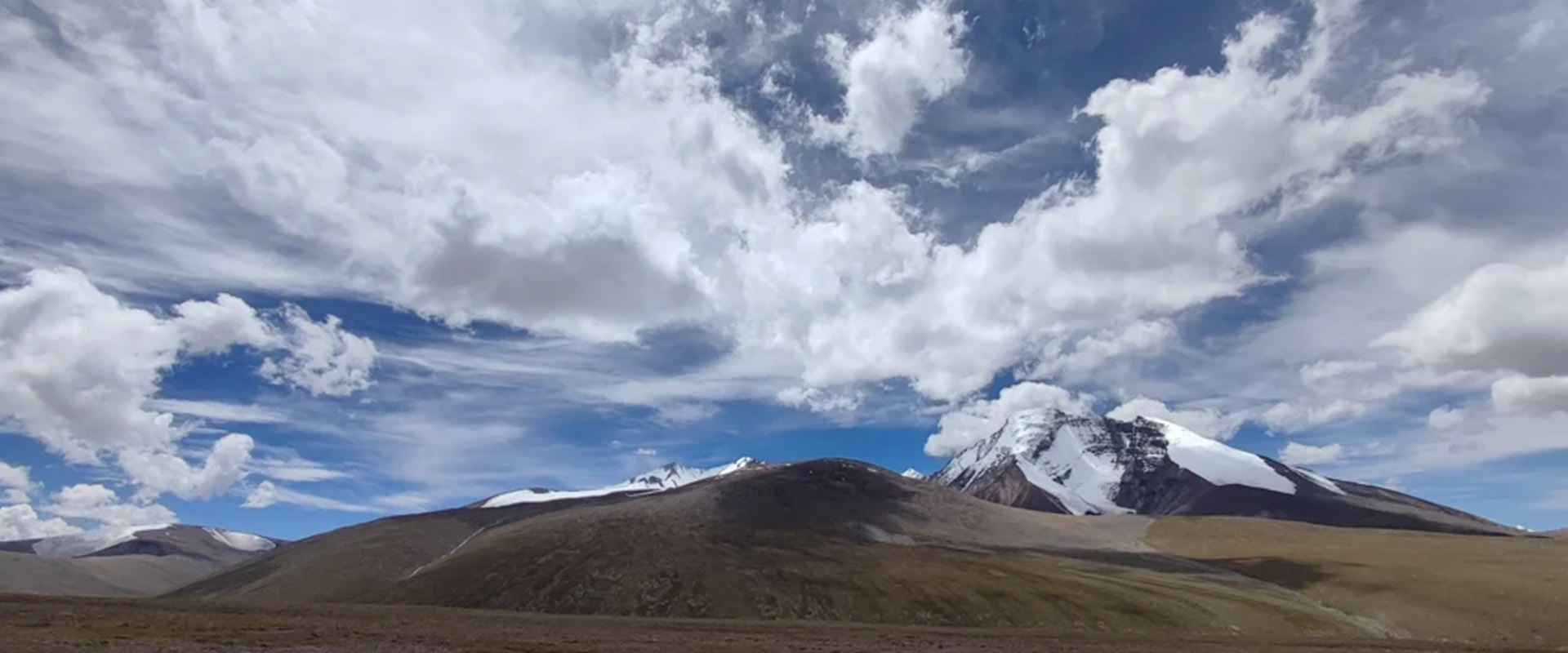
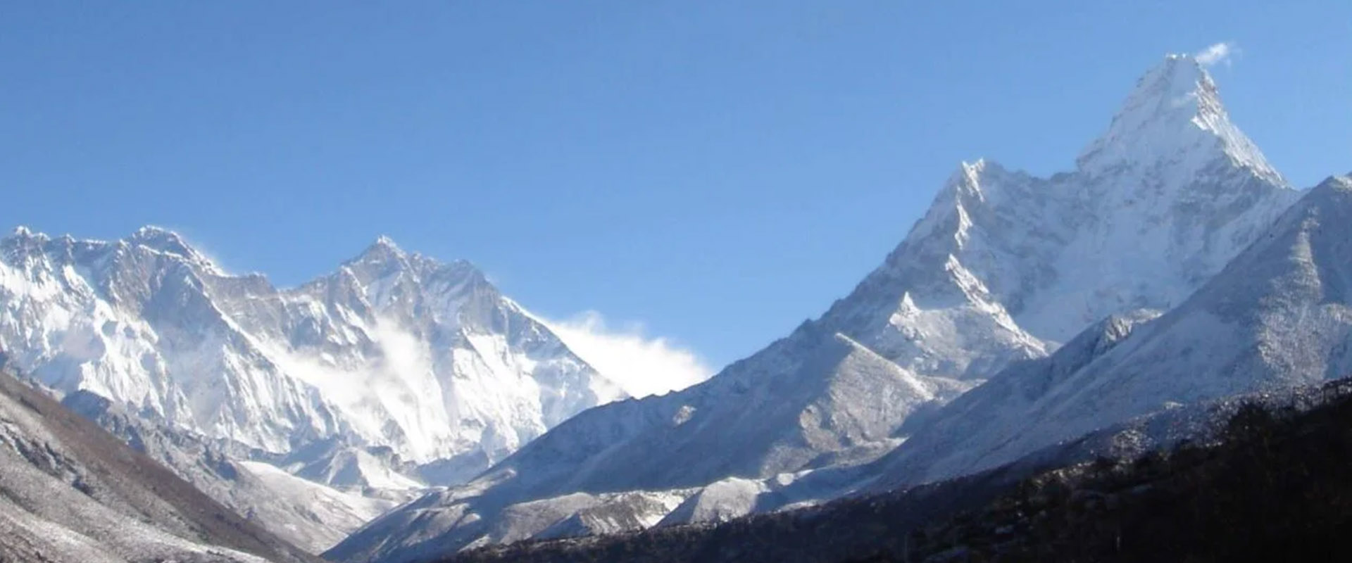
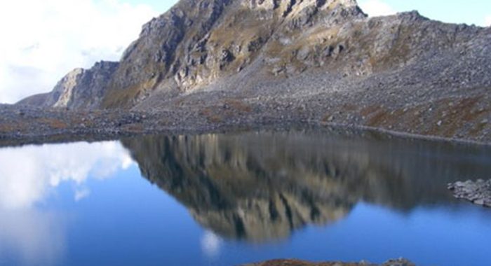
The Sarutal Trek is a hidden high-altitude lake trek in the Uttarkashi district of Uttarakhand (Garhwal Himalayas). It is a peaceful and less-crowded Himalayan trail that combines alpine wilderness, spiritual significance, and raw mountain beauty. The trek reaches up to 4,200 m (13,780 ft) and leads to the sacred Sarutal Lake, associated with the Maa Saraswati Temple.

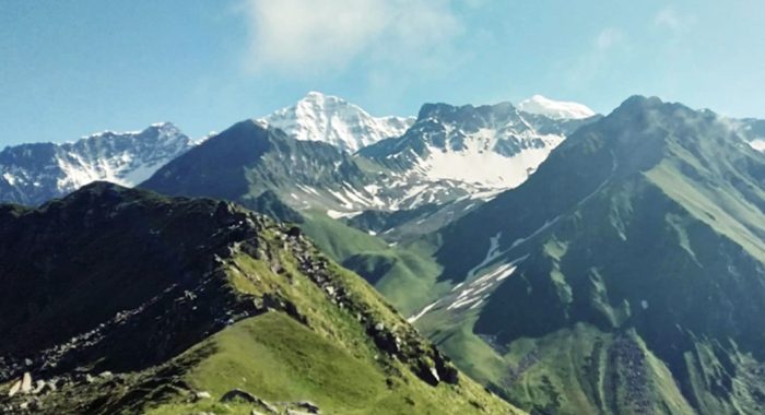
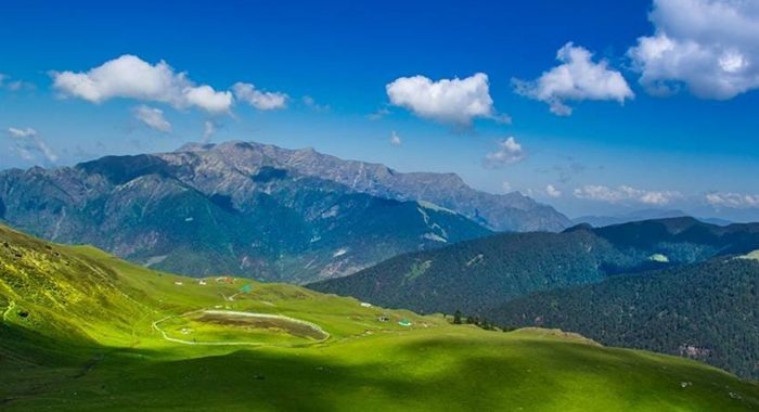
This trek is known for its serene silence, untouched landscapes, and gradual transition from dense pine forests to wide alpine meadows. Along the way, trekkers experience changing Himalayan ecosystems, from lush greenery to rugged high-altitude terrain. The trail also offers stunning views of snow-clad peaks and deep Garhwal valleys.

Sarutal is not just a trek but a spiritual journey into nature, where the calm lake and surrounding mountains create a deeply meditative atmosphere. It is ideal for nature lovers, photographers, spiritual seekers, and offbeat adventure explorers who want to experience the Himalayas in their purest form.

Short Itinerary

Sarutal Trek – Short Itinerary (6 Days)

Day 1: Dehradun → Kotgaon (200 km | 8–9 hrs)
  • Scenic drive via Mussoorie, Mori, Netwar
  • Reach Kotgaon base village
  • Overnight stay in a homestay
Day 2: Kotgaon → Taluka → Dodiya Thach (8 km trek | 4–5 hrs)
  • Short drive to Taluka
  • Trek through forests & river streams
  • Camp at Dodiya Thach
Day 3: Dodiya Thach → Kota Damni (7 km | 5–6 hrs)
  • Gradual ascent through forests & meadows
  • Reach high camp at Kota Damni
Day 4: Kota Damni → Sarutal → Kota Damni (8 km | 5–6 hrs)
  • Summit push to Sarutal Lake (4,200 m)
  • Visit Maa Saraswati Temple site
  • Return to camp
Day 5: Kota Damni → Taluka → Kotgaon (15 km trek + drive)
  • Long descent through forests
  • Drive back to Kotgaon
  • Rest in homestay
Day 6: Kotgaon → Dehradun (200 km | 8–9 hrs)
  • Return journey to Dehradun
  • Trip ends

Detailed Itinerary

Sarutal Trek – Detailed Itinerary (Enhanced Version)

Day 1: Drive from Dehradun to Kotgaon (The Base Camp Gateway)
  • Drive Distance & Time: ~200 km | 8–9 hours
  • Altitude: Kotgaon (~2,000 m approx.)

The Experience:
Your journey begins early morning from Dehradun as you join the expedition team and board a comfortable mountain transit vehicle. The drive takes you deep into the untouched Garhwal Himalayas, gradually leaving behind city life and entering a world of river valleys and dense mountain forests.

The route passes through Mussoorie, Purola, Mori, and Netwar, following the pristine flow of the Tons and Supin river valleys. Along the way, you witness changing landscapes—lush green hills slowly transforming into rugged Himalayan terrain, wooden bridges, and traditional villages.

By late afternoon, you arrive at the culturally rich and peaceful Kotgaon village, surrounded by apple orchards, terraced fields, and alpine scenery. The calm atmosphere immediately sets the tone for your offbeat Himalayan expedition.

  • Accommodation: Cozy homestay / traditional guesthouse in Kotgaon
  • Evening: Briefing by trek leader, gear check, acclimatization walk, dinner
Day 2: Drive to Taluka & Trek to Dodiya Thach
  • Drive Distance: 15 km (Kotgaon → Taluka)
  • Trek Distance & Time: 8 km | 4–5 hours

The Experience:
After an early breakfast, a short but scenic jeep ride takes you to Taluka, the official starting point of the trek. From here, your real mountain journey begins.

The trail follows the Supin River, crossing wooden bridges, small waterfalls, and crystal-clear streams. The path gradually ascends through dense forests of oak, pine, and deodar, filled with birdsong and natural silence.

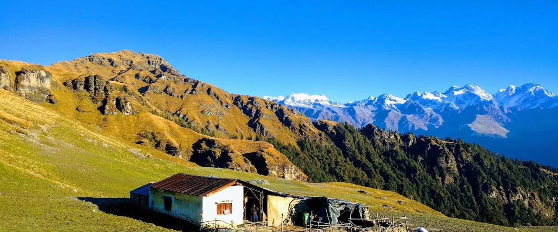
As altitude increases, the forest begins to open into alpine clearings. By afternoon, you reach the peaceful meadow campsite of Dodiya Thach, surrounded by untouched wilderness and mountain air.

  • Accommodation: Alpine wilderness tents at Dodiya Thach
  • Evening: Tea, rest, campsite exploration, stargazing
Day 3: Trek from Dodiya Thach to Kota Damni (Taloti)
  • Trek Distance & Time: 7 km | 5–6 hours

The Experience:
Wake up to crisp Himalayan air and the sound of distant river flow. Today’s trail becomes more scenic and open as you gain altitude.

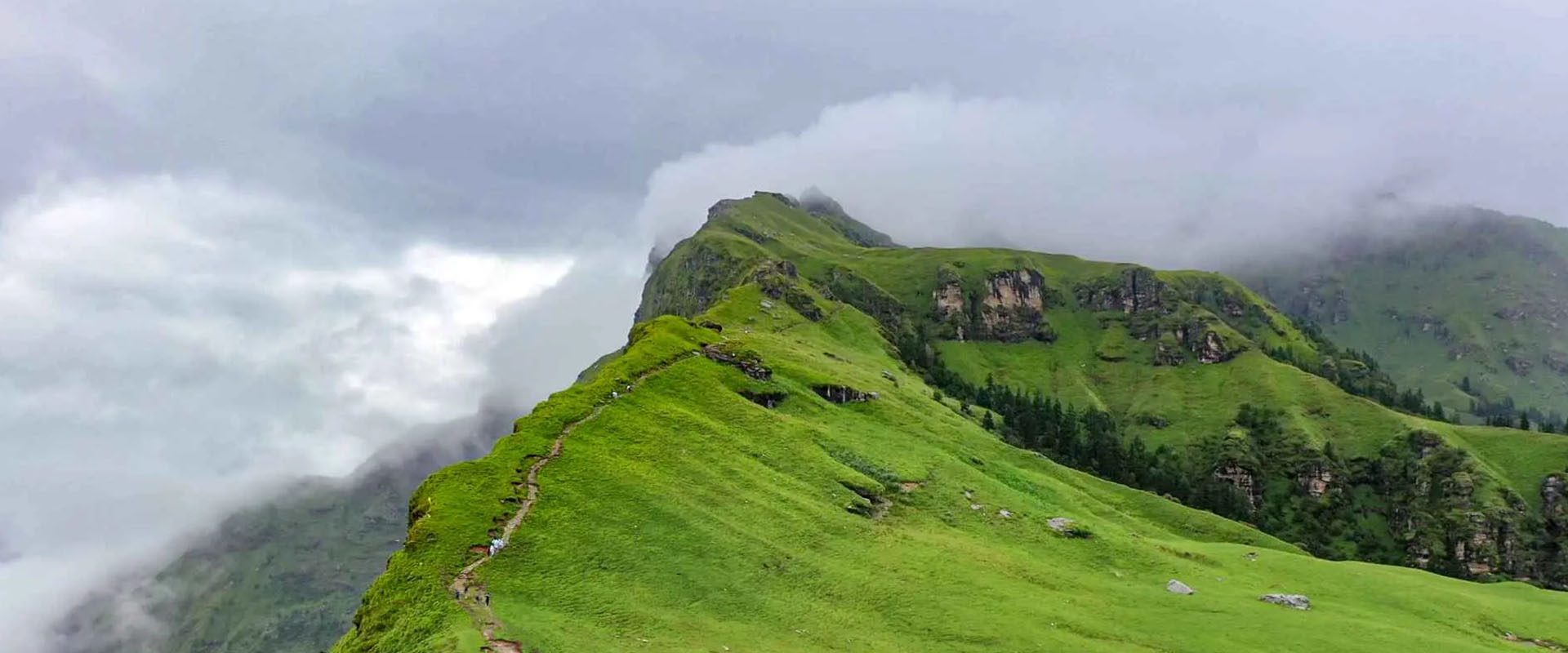
You walk through classic zig-zag mountain paths, gradually leaving thick forests behind and entering vast alpine meadows filled with wildflowers and natural grasslands. The landscape opens up dramatically, offering panoramic views of surrounding ridges and valleys.

By late afternoon, you reach Kota Damni (Taloti)—a high-altitude campsite known for its raw beauty, silence, and untouched environment.

  • Accommodation: Alpine wilderness tents at Kota Damni
  • Evening: Hot meal, rest, acclimatization focus
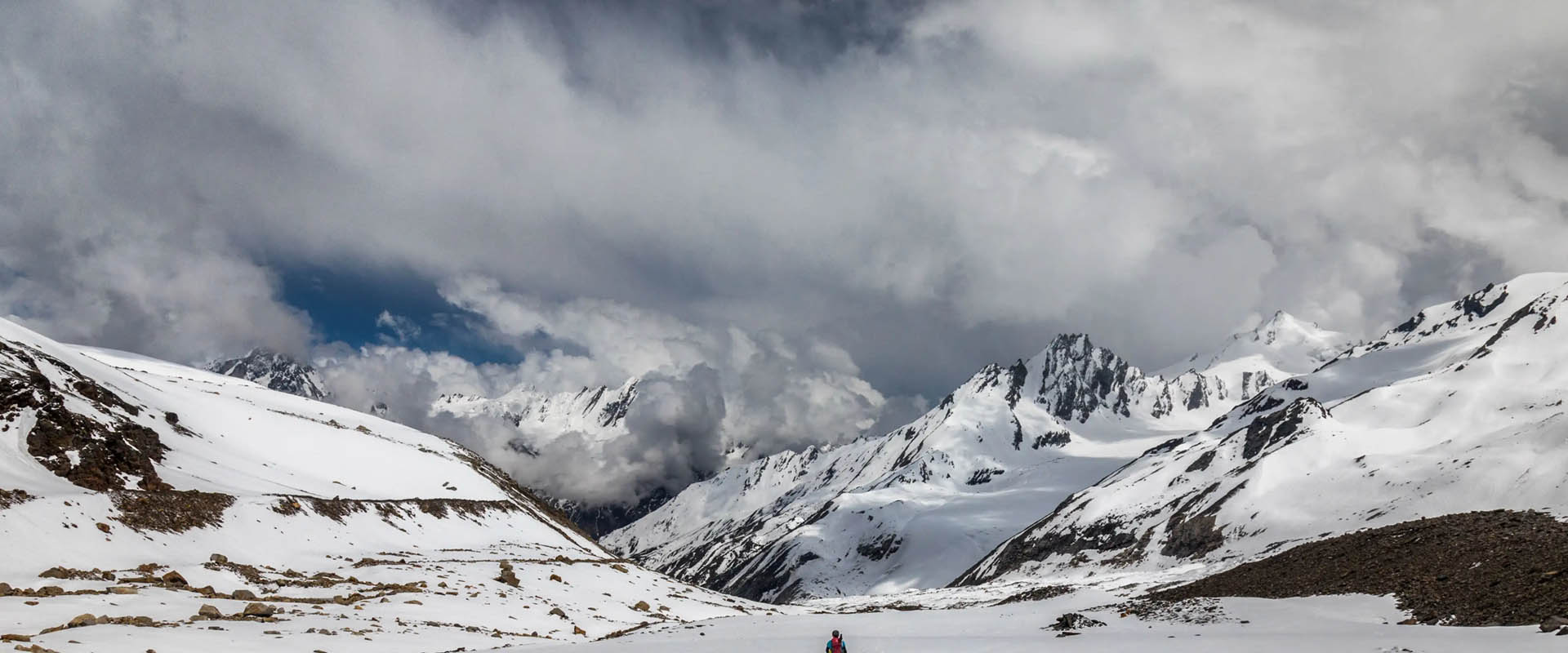
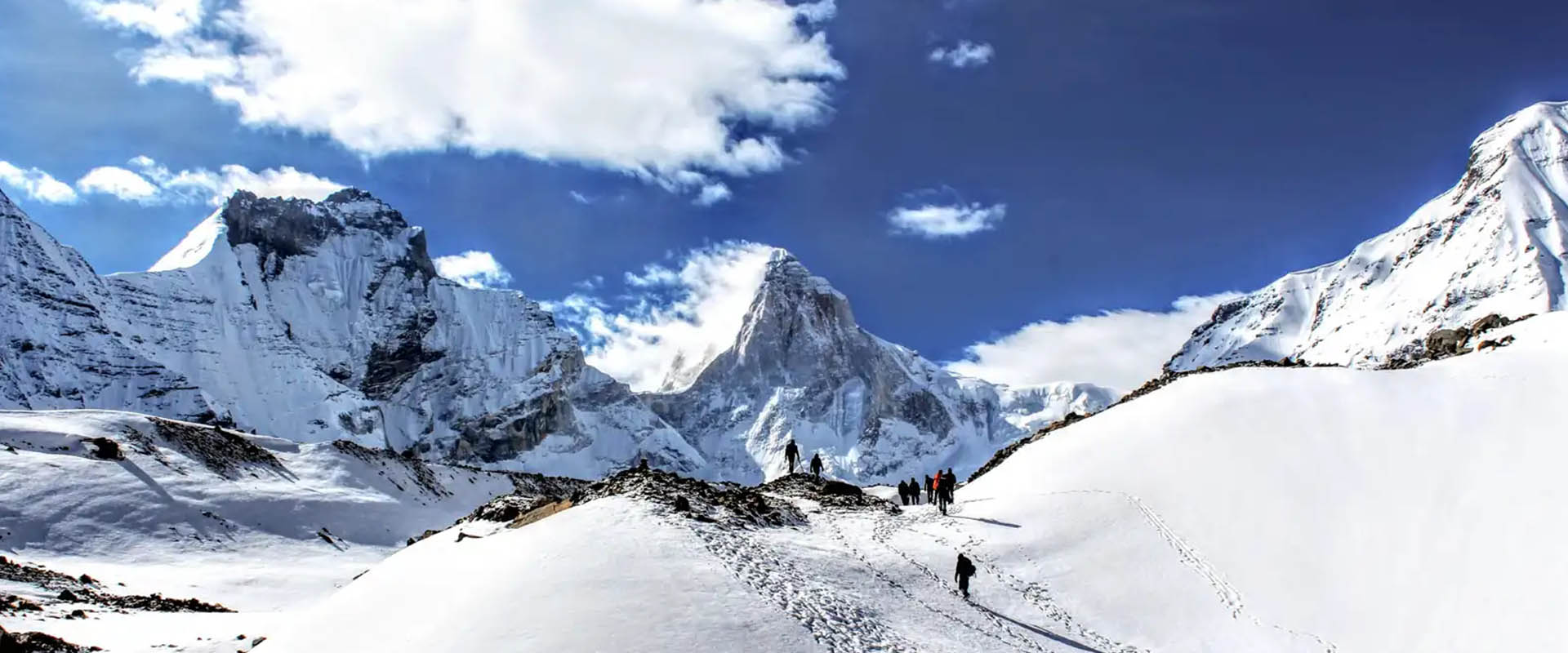
Day 4: Summit Push to Sarutal (4,200 m) & Return
  • Trek Distance & Time: ~8 km round trip | 5–6 hours

The Experience:
This is the most important and spiritual day of the expedition. The climb begins early morning under golden Himalayan light.

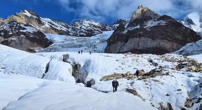
As you ascend above 4,000 meters, the terrain becomes more dramatic—rocky ridges, alpine silence, and vast mountain amphitheaters surround you. Slowly, the sacred basin of Sarutal Lake (4,200 m) comes into view.

At the lake, you experience complete tranquility. The sacred waters of Sarutal reflect the surrounding peaks, and the Maa Saraswati Temple site adds deep spiritual significance to the journey. Time is spent in meditation, photography, and soaking in the Himalayan energy.

After spending quality time at the summit, you descend carefully back to Kota Damni campsite.

  • Accommodation: Alpine tents at Kota Damni
  • Evening: Celebration dinner, rest, recovery
Day 5: Long Descent to Taluka & Return to Kotgaon
  • Trek Distance: ~15 km descent | 6–7 hours
  • Drive Distance: 15 km to Kotgaon

The Experience:
After breakfast, begin a long and rewarding descent through forests, ridges, and meadows. This stretch allows you to retrace your path while enjoying different perspectives of the same landscape.

The trail gradually descends back to Taluka, where vehicles await. From here, a short drive takes you back to the comfort of Kotgaon village.

The evening is relaxed, marking the completion of the high-altitude section of the trek.

  • Accommodation: Homestay in Kotgaon
  • Evening: Hot meals, rest, reflection time
Day 6: Kotgaon → Dehradun (Return Journey)
  • Drive Distance & Time: ~200 km | 8–9 hours

The Experience:
After breakfast, begin your final journey back to Dehradun. The drive retraces the beautiful Himalayan valleys, rivers, and mountain roads one last time.

As you descend into the plains, the majestic peaks slowly fade behind you, leaving you with memories of untouched meadows, sacred waters, and raw Himalayan wilderness.

  • Trip Ends: Dehradun drop

Rental Gear List (Pre-booking required)

  • Trekking Poles: ₹200 (adjustable) / ₹150 (fixed)
  • RainPoncho: ₹200
  • Flask: ₹300
  • Gloves: ₹150/₹250
  • LunchBox&Tiffin Boxes: ₹250
  • Headlamps: ₹150
  • Extra WarmJackets: ₹550
  • Trekking Shoes: ₹550
  • Trekking Pants: ₹450

Note: Reserve rental gear in advance. Rental fees may apply.

Inclusions

  • Transport: Dehradun – Harsil – Gangotri – Dehradun
  • Accommodation: 2 nights in Harsil Cottage, 3 nights in tents (Double/Triple sharing)
  • Meals as per itinerary (veg only)
  • Certified trek leader, guides, support staff
  • Camping gear: tents, sleeping bags, mattresses
  • All necessary permits and forest fees
  • First aid kit, oxygen cylinder
  • Mules/porters for common gear

Exclusions

  • Personal expenses (tips, shopping, etc.)
  • Bottled water or aerated drinks
  • Insurance, emergency evacuation, and rescue
  • Any meals not mentioned above
  • Personal trekking gear (available on rent)
  • Porter for personal luggage (available at extra cost)
  • Anything not mentioned in ‘Inclusions’

Triund Trek

kailash-mansarova03
previous arrow
next arrow

Triund Trek

Region

Himachal Pradesh

Duration

2 Days, 1 Nights

Difficulty

Easy to Moderate

Altitude

9,350 Ft

Distance

14 Km

Trek Price: ₹16,999

Add-ons

Items Price (₹) Items Price (₹)
River Rafting (with Safety Kayaker) 1500 Bungee Jumping 2500
Offloading (Backpack) 1600 Single Occupancy Tent 1600
Trekking Shoes Rental 550 Down Jacket Rental 550
Trekking Pole Rental 250 Poncho / Rain Cover 200
Gloves 200 Thermal Water Bottle 300
Insurance 100 / day

Overview

Triund Trek: The Crown Jewel of Dharamshala

Experience the perfect weekend mountain escape with Team Himalayan Dérive. The Triund Trek is a legendary, highly accessible trail rising above the vibrant Tibetan hub of McLeod Ganj in the Kangra Valley. Offering unparalleled, up-close views of the snow-capped Moon Peak and the majestic Dhauladhar Range, this trek is a favorite for both absolute beginners and seasoned hikers.

The trail gradually ascends through beautiful oak and rhododendron forests, opening up to sweeping views of the valley below and dramatic Himalayan ridgelines above. At an altitude of around 2,850 meters, Triund offers one of the most rewarding panoramic camping experiences in the lower Himalayas, with unforgettable sunsets and star-filled night skies.

This direct 2-Day / 1-Night package is fully curated for your comfort and safety. Leave the heavy lifting to us as we provide complete camping infrastructure, hot meals, and certified professional guiding so you can focus entirely on the breathtaking Himalayan vistas and the peaceful mountain atmosphere.

Short Itinerary

Triund Trek – Short Itinerary

Day 1: McLeod Ganj → Triund (7 km | 4–5 hrs)
  • Trek via Gallu Devi Temple
  • Forest trail + 22 Curves climb
  • Reach Triund Top
  • Sunset views + camping

Stay: Camps at Triund

Day 2: Triund → McLeod Ganj (7 km | 3–4 hrs)
  • Sunrise at campsite
  • Breakfast + descent
  • Return to McLeod Ganj

Trip Ends: McLeod Ganj drop

Detailed Itinerary

Triund Trek – Detailed Itinerary

Day 1: Ascent to Triund Top (Dhauladhar Ridge)
  • Meet at McLeod Ganj and transfer to Gallu Devi Temple (starting point)
  • Gradual trek through dense forests of oak, pine, and rhododendron
  • Scenic break at Magic View Café overlooking Kangra Valley
  • Final ascent via steep “22 Curves” switchback trail
  • Arrive at Triund Top (2,850 m) with panoramic Himalayan views
  • Enjoy sunset over Dhauladhar snow peaks
  • Hot dinner and overnight stay in alpine dome tents under starry sky
Day 2: Descent to McLeod Ganj
  • Early morning sunrise view over snow-clad mountains
  • Breakfast at campsite with tea/coffee
  • Packed descent through forest trail
  • Reach Gallu Devi Temple by afternoon
  • Short drive back to McLeod Ganj

Trip Ends: Return with Himalayan memories

Rental Gear List (Pre-booking required)

  • Trekking Poles: ₹200 (adjustable) / ₹150 (fixed)
  • RainPoncho: ₹200
  • Flask: ₹300
  • Gloves: ₹150/₹250
  • LunchBox&Tiffin Boxes: ₹250
  • Headlamps: ₹150
  • Extra WarmJackets: ₹550
  • Trekking Shoes: ₹550
  • Trekking Pants: ₹450

Note: Reserve rental gear in advance. Rental fees may apply.

Inclusions

  • Transport: Dehradun – Harsil – Gangotri – Dehradun
  • Accommodation: 2 nights in Harsil Cottage, 3 nights in tents (Double/Triple sharing)
  • Meals as per itinerary (veg only)
  • Certified trek leader, guides, support staff
  • Camping gear: tents, sleeping bags, mattresses
  • All necessary permits and forest fees
  • First aid kit, oxygen cylinder
  • Mules/porters for common gear

Exclusions

  • Personal expenses (tips, shopping, etc.)
  • Bottled water or aerated drinks
  • Insurance, emergency evacuation, and rescue
  • Any meals not mentioned above
  • Personal trekking gear (available on rent)
  • Porter for personal luggage (available at extra cost)
  • Anything not mentioned in ‘Inclusions’

Gulabi Kantha Trek

kailash-mansarova03
previous arrow
next arrow

Gulabi Kantha Trek

Region

Uttarakhand

Duration

5 Days, 4 Nights

Difficulty

Moderate

Altitude

13,200 ft

Distance

22 km

Trek Price: ₹16,999

Add-ons

Items Price (₹) Items Price (₹)
River Rafting (with Safety Kayaker) 1500 Bungee Jumping 2500
Offloading (Backpack) 1600 Single Occupancy Tent 1600
Trekking Shoes Rental 550 Down Jacket Rental 550
Trekking Pole Rental 250 Poncho / Rain Cover 200
Gloves 200 Thermal Water Bottle 300
Insurance 100 / day

Overview

Gulabi Kantha Trek: The Pristine Secret of the Yamunotri Valley

Escape the crowded commercial trails and step into the untouched wilderness of the Gulabi Kantha Trek with Team Himalayan Dérive. Tucked away in the sacred Yamunotri region of the Garhwal Himalayas, this hidden gem offers a perfect blend of adventure, solitude, and breathtaking natural beauty. Known for its vast alpine meadows, dense oak and rhododendron forests, and panoramic mountain landscapes, Gulabi Kantha remains one of Uttarakhand’s most rewarding offbeat trekking experiences.

Scaling up to approximately 4,000 meters (13,200 ft), the trek takes you through remote Himalayan villages, pristine forest trails, and expansive high-altitude grasslands before reaching the spectacular summit ridge. From the top, trekkers are rewarded with magnificent 360-degree views of iconic Himalayan peaks, including Bandarpoonch, Swargarohini, Kala Nag, Kalindi Peak, and the Yamunotri range.

Whether you are an experienced trekker seeking a peaceful alternative to crowded routes or a nature enthusiast looking to explore the untouched beauty of the Garhwal Himalayas, the Gulabi Kantha Trek promises an unforgettable journey. With its rich biodiversity, serene campsites, stunning sunrises, and unmatched mountain vistas, this 5-day adventure showcases the raw and authentic charm of the Indian Himalayas.

Short Itinerary

Short Itinerary – Gulabi Kantha Trek (5 Days)

Day 1: Dehradun → Hanuman Chatti
  • Drive: ~180 km (6–7 hrs)
  • Overnight stay in guest house
Day 2: Hanuman Chatti → Kandola Chhani
  • Trek: ~5 km (4–5 hrs)
  • Forest trail camp
  • Overnight camping
Day 3: Kandola Chhani → Seema Thatch
  • Trek: ~6 km (6–7 hrs)
  • Alpine meadows campsite
  • Overnight camping
Day 4: Seema Thatch → Gulabi Kantha Summit → Kandola Chhani
  • Trek: ~12 km (10 hrs total)
  • Summit at 13,200 ft
  • Return & camp stay
Day 5: Kandola Chhani → Hanuman Chatti → Dehradun
  • Trek: ~5 km (3–4 hrs)
  • Drive: ~180 km (6–7 hrs)
  • Trip ends in Dehradun

Detailed Itinerary

Detailed Itinerary – Gulabi Kantha Trek

Day 1: Drive from Dehradun to Hanuman Chatti

Drive Distance & Time: 180 km | 6–7 hours
Altitude: 2,100 m (6,800 ft)

The Experience:
Your journey begins early morning from Dehradun as you drive through the scenic Himalayan route via Mussoorie and along the pristine Yamuna River. The road gradually ascends into the Garhwal Himalayas, offering beautiful views of valleys, forests, and river bends. By afternoon, you arrive at Hanuman Chatti, the gateway to the Yamunotri region. After check-in, meet your trek leader for briefing and preparation.

Accommodation: Guest house / homestay in Hanuman Chatti

Day 2: Trek from Hanuman Chatti to Kandola Chhani

Trek Distance & Time: 5 km | 4–5 hours
Altitude: 2,700 m (8,900 ft)

The Experience:
After breakfast, begin your trek through dense oak, pine, and rhododendron forests. The trail offers peaceful surroundings, bird sounds, and gradual elevation gain. As you move higher, the forest canopy becomes thicker and more mystical. By afternoon, reach Kandola Chhani, a scenic forest clearing where your first campsite is set amidst nature.

Accommodation: Alpine tents at Kandola Chhani

Day 3: Trek from Kandola Chhani to Seema Thatch

Trek Distance & Time: 6 km | 6–7 hours
Altitude: 3,474 m (11,400 ft)

The Experience:
Today’s trek takes you deeper into high-altitude terrain. The forest slowly disappears, opening into vast alpine meadows (bugyals). The landscape becomes wide, green, and dramatic with stunning Himalayan views. As you reach Seema Thatch, enjoy panoramic scenery, cool winds, and a peaceful campsite perfect for stargazing.

Accommodation: Alpine tents at Seema Thatch

Day 4: Summit Push – Gulabi Kantha & Return to Kandola Chhani

Trek Distance & Time: 12 km | ~10 hours
Altitude: 4,000 m (13,200 ft)

The Experience:
Start early morning for the summit push to Gulabi Kantha (13,200 ft). The climb is steep but rewarding, leading you to a breathtaking ridge viewpoint. From the top, enjoy a 360-degree Himalayan panorama featuring peaks like Bandarpoonch, Swargarohini, Kala Nag, and the Yamunotri range. After spending time at the summit, descend back to Seema Thatch, have lunch, and continue further down to Kandola Chhani for overnight rest.

Accommodation: Alpine tents at Kandola Chhani

Day 5: Descent to Hanuman Chatti & Drive to Dehradun

Trek Distance & Time: 5 km | 3–4 hours
Drive Distance & Time: 180 km | 6–7 hours
Altitude: 2,100 m (6,800 ft)

The Experience:
Enjoy your final Himalayan morning before beginning the descent back to Hanuman Chatti through forest trails. After reaching the base, board your vehicle for the scenic drive back to Dehradun. The journey ends by evening as you descend from the mountains carrying unforgettable memories of the Gulabi Kantha expedition.

Trip Ends: Dehradun Drop

Rental Gear List (Pre-booking required)

  • Trekking Poles: ₹200 (adjustable) / ₹150 (fixed)
  • RainPoncho: ₹200
  • Flask: ₹300
  • Gloves: ₹150/₹250
  • LunchBox&Tiffin Boxes: ₹250
  • Headlamps: ₹150
  • Extra WarmJackets: ₹550
  • Trekking Shoes: ₹550
  • Trekking Pants: ₹450

Note: Reserve rental gear in advance. Rental fees may apply.

Inclusions

  • Transport: Dehradun – Harsil – Gangotri – Dehradun
  • Accommodation: 2 nights in Harsil Cottage, 3 nights in tents (Double/Triple sharing)
  • Meals as per itinerary (veg only)
  • Certified trek leader, guides, support staff
  • Camping gear: tents, sleeping bags, mattresses
  • All necessary permits and forest fees
  • First aid kit, oxygen cylinder
  • Mules/porters for common gear

Exclusions

  • Personal expenses (tips, shopping, etc.)
  • Bottled water or aerated drinks
  • Insurance, emergency evacuation, and rescue
  • Any meals not mentioned above
  • Personal trekking gear (available on rent)
  • Porter for personal luggage (available at extra cost)
  • Anything not mentioned in ‘Inclusions’

Madhyamaheshwar Trek

kailash-mansarova03
previous arrow
next arrow

Madhyamaheshwar Trek

Region

Uttarakhand

Duration

4 Days, 3 Nights

Difficulty

Moderate

Altitude

11,480 Ft

Distance

52 Km

Trek Price: ₹16,999

Add-ons

Items Price (₹) Items Price (₹)
River Rafting (with Safety Kayaker) 1500 Bungee Jumping 2500
Offloading (Backpack) 1600 Single Occupancy Tent 1600
Trekking Shoes Rental 550 Down Jacket Rental 550
Trekking Pole Rental 250 Poncho / Rain Cover 200
Gloves 200 Thermal Water Bottle 300
Insurance 100 / day

Overview

Madhyamaheshwar Trek: 4-Day Sacred Wilderness Journey

Journey to the most architecturally profound and peaceful shrine of the sacred Panch Kedar with Team Himalayan Dérive. The Madhyamaheshwar Trek (also known as Madmaheshwar) is an extraordinary pilgrimage and wilderness trail that leads you deep into the Kedarnath Wildlife Sanctuary of the Garhwal Himalayas. Trekking along rushing glacial rivers, through dense emerald canopies, and emerging onto flawless alpine meadows, this trail offers unmatched spiritual solace. Standing at the ancient temple, you will look directly at the sensational, colossal wall of the Chaukhamba massif.

Nestled at an altitude of approximately 11,500 ft (3,505 m), Madhyamaheshwar Temple is one of the revered shrines of the Panch Kedar and holds immense significance for devotees of Lord Shiva. The trek offers a perfect blend of spirituality, adventure, and natural beauty, taking you through traditional Himalayan villages, dense oak and rhododendron forests, crystal-clear mountain streams, and vast high-altitude meadows.

Whether you are a pilgrim seeking divine blessings or a nature enthusiast looking to explore the untouched beauty of the Garhwal Himalayas, this trek promises an unforgettable experience. With breathtaking views of Chaukhamba, Mandani, Kedarnath, and Neelkanth peaks, peaceful temple surroundings, and the serene wilderness of the Kedarnath Sanctuary, the Madhyamaheshwar Trek stands as one of the most rewarding spiritual journeys in the Indian Himalayas.

Short Itinerary

Short Itinerary – Madhyamaheshwar Trek (4 Days)

Day 1: Rishikesh → Ransi → Goundar Village
  • Drive: ~215 km (7–8 hrs)
  • Trek: 4 km (1.5–2 hrs)
  • Overnight stay at Goundar Village
Day 2: Goundar → Madhyamaheshwar Temple
  • Trek: 11 km (5–6 hrs)
  • Visit Madhyamaheshwar Temple
  • Overnight stay near the temple
Day 3: Budha Madhyamaheshwar Excursion → Goundar
  • Trek: 15 km (7–8 hrs total)
  • Sunrise views from Budha Madhyamaheshwar
  • Return to Goundar Village
Day 4: Goundar → Ransi → Rishikesh
  • Trek: 4 km (2 hrs)
  • Drive: ~215 km (7–8 hrs)
  • Trip concludes in Rishikesh

Detailed Itinerary

Detailed Itinerary – Madhyamaheshwar Trek

Day 1: Drive from Rishikesh to Ransi & Trek to Goundar Village

Drive Distance & Time: ~215 km | 7–8 hours
Trek Distance & Time: 4 km | 1.5–2 hours

The Experience:
Your journey begins early morning from Rishikesh as you drive through the scenic river valleys of the Alaknanda and Mandakini. En route, witness the sacred confluences of Devprayag and Rudraprayag while enjoying spectacular views of the Garhwal Himalayas. Upon reaching Ransi Village, the trek begins with a pleasant trail through forests and mountain paths leading to Goundar Village. Located at the confluence of the Madmaheshwar Ganga and Martyenda Ganga rivers, Goundar offers a peaceful introduction to the wilderness of the Kedarnath Wildlife Sanctuary.

Accommodation: Traditional village homestay in Goundar.

Day 2: Trek from Goundar Village to Madhyamaheshwar Temple

Trek Distance & Time: 11 km | 5–6 hours

The Experience:
After breakfast, begin a steady ascent through dense oak and rhododendron forests. The trail passes through scenic locations such as Bantoli, Khatara, and Nanu, offering beautiful views of streams, valleys, and mountain ridges. As the forest gradually opens up, the spectacular alpine meadow of Madhyamaheshwar appears before you. Nestled amidst lush grasslands, the ancient stone temple dedicated to Lord Shiva stands against the magnificent backdrop of Chaukhamba, Mandani, and Kedar Dome peaks. In the evening, attend the peaceful temple aarti and soak in the spiritual atmosphere.

Accommodation: Guesthouse or homestay near Madhyamaheshwar Temple.

Day 3: Budha Madhyamaheshwar Excursion & Return to Goundar

Trek Distance & Time: 2 km ascent + 13 km descent | 7–8 hours

The Experience:
Wake up before sunrise and trek to Budha Madhyamaheshwar, one of the finest viewpoints in the Garhwal Himalayas. The steep climb rewards you with breathtaking panoramic views of the Chaukhamba massif reflected in sacred alpine ponds. Witness the first rays of sunlight illuminating the snow-covered peaks, creating a truly unforgettable Himalayan experience. After spending time at the viewpoint, return to the temple for breakfast before descending through forests and mountain trails back to Goundar Village.

Accommodation: Homestay in Goundar Village.

Day 4: Trek from Goundar to Ransi & Drive to Rishikesh

Trek Distance & Time: 4 km | 2 hours
Drive Distance & Time: ~215 km | 7–8 hours

The Experience:
Enjoy a relaxed morning amidst the serene mountain surroundings before completing the final stretch of the trek back to Ransi Village. From here, board your vehicle and begin the scenic drive back to Rishikesh through winding mountain roads, river valleys, and picturesque Himalayan landscapes. Arrive in Rishikesh by evening, bringing your spiritual and wilderness journey to a memorable conclusion.

Trip Ends: Rishikesh Drop.

Rental Gear List (Pre-booking required)

  • Trekking Poles: ₹200 (adjustable) / ₹150 (fixed)
  • RainPoncho: ₹200
  • Flask: ₹300
  • Gloves: ₹150/₹250
  • LunchBox&Tiffin Boxes: ₹250
  • Headlamps: ₹150
  • Extra WarmJackets: ₹550
  • Trekking Shoes: ₹550
  • Trekking Pants: ₹450

Note: Reserve rental gear in advance. Rental fees may apply.

Inclusions

  • Transport: Dehradun – Harsil – Gangotri – Dehradun
  • Accommodation: 2 nights in Harsil Cottage, 3 nights in tents (Double/Triple sharing)
  • Meals as per itinerary (veg only)
  • Certified trek leader, guides, support staff
  • Camping gear: tents, sleeping bags, mattresses
  • All necessary permits and forest fees
  • First aid kit, oxygen cylinder
  • Mules/porters for common gear

Exclusions

  • Personal expenses (tips, shopping, etc.)
  • Bottled water or aerated drinks
  • Insurance, emergency evacuation, and rescue
  • Any meals not mentioned above
  • Personal trekking gear (available on rent)
  • Porter for personal luggage (available at extra cost)
  • Anything not mentioned in ‘Inclusions’

Ali Bedni Bugyal Trek

audens-col02
previous arrow
next arrow

Ali Bedni Bugyal Trek

Region

Uttarakhand

Duration

5 Days / 4 Nights

Difficulty

Easy to Moderate

Altitude

11,686 ft

Distance

22 Km

Trek Price: ₹11,999

Add-ons

Items Price (₹) Items Price (₹)
River Rafting (with Safety Kayaker) 1500 Bungee Jumping 2500
Offloading (Backpack) 1600 Single Occupancy Tent 1600
Trekking Shoes Rental 550 Down Jacket Rental 550
Trekking Pole Rental 250 Poncho / Rain Cover 200
Gloves 200 Thermal Water Bottle 300
Insurance 100 / day

Overview

Ali Bedni Bugyal Trek: Walk Upon Asia’s Grandest Alpine Meadows

Welcome to the Ali Bedni Bugyal Trek—a breathtaking journey into the heart of the Garhwal Himalayas that unveils two of the largest and most spectacular high-altitude twin meadows in Asia. Brought to you by Team Himalayan Dérive, this 5-day adventure offers an unforgettable experience where vast alpine landscapes meet the towering presence of Mt. Trishul and Nanda Ghunti, creating a truly majestic Himalayan panorama.

This trek is widely regarded as one of the most scenic high-altitude meadow journeys in Uttarakhand, combining natural beauty, cultural richness, and peaceful wilderness. The trail winds through dense oak and rhododendron forests, traditional Himalayan villages, and eventually opens into endless rolling grasslands of Ali Bugyal and Bedni Bugyal, where the sky feels within reach and the mountains dominate the horizon.

Whether you are a beginner stepping into your first major Himalayan trek or an experienced trekker seeking unmatched alpine views, this eco-friendly route offers a perfect balance of adventure and serenity. The journey is moderately easy yet visually spectacular, making it a favorite among nature lovers, photographers, and explorers who wish to witness the grandeur of the Garhwal Himalayas up close.

Short Itinerary

Short Itinerary – Ali Bedni Bugyal Trek

Day 1: Dehradun/Rishikesh to Wan Village
  • Drive: ~290 km | 10–11 hours
  • Overnight stay in Wan Village
Day 2: Wan Village to Geruli Patal
  • Trek: 5 km | 4–5 hours
  • Altitude: 10,000 ft
  • Overnight camping at Geruli Patal

Day 3: Geruli Patal to Ali & Bedni Bugyal Exploration

  • Trek: 6–7 km | 5–6 hours
  • Altitude: 11,686 ft
  • Overnight camping near Bedni Bugyal
Day 4: Ali Bedni Bugyal to Wan Village
  • Trek: 10–12 km | 5–6 hours
  • Overnight stay in Wan Village
Day 5: Wan Village to Rishikesh/Dehradun
  • Drive: ~290 km | 10–11 hours
  • Trek concludes with drop at Dehradun/Rishikesh

Detailed Itinerary

Ali Bedni Bugyal Trek Detailed Itinerary

Day 1: Drive from Dehradun/Rishikesh to Wan Village
  • Drive Distance & Time: ~290 km | 10–11 hours drive
  • Altitude: Dehradun (1,470 ft) to Wan Village (8,000 ft)

The Experience:
Your journey begins early morning from Dehradun or Rishikesh, as you board a comfortable mountain vehicle for a scenic drive deep into the Garhwal Himalayas. The route follows the sacred rivers of Uttarakhand, offering mesmerizing views of river valleys, cascading waterfalls, and terraced hillsides.

You pass through spiritually significant confluences such as Devprayag and Karnaprayag, where rivers merge into the holy Ganga system. As the road climbs higher, the landscape shifts from lush valleys to dense pine forests and winding mountain roads carved into steep cliffs.

By late afternoon, you arrive at the peaceful and remote Wan Village, surrounded by traditional stone houses, terraced fields, and towering Himalayan ridges.

  • Accommodation: Cozy traditional mountain guest house or homestay in Wan
Day 2: Trek from Wan Village to Geruli Patal (Ghaeroli Patal)
  • Trek Distance & Time: 5 km | 4–5 hours trek
  • Altitude: 10,000 ft at Geruli Patal

The Experience:
After breakfast, your trekking adventure officially begins. The trail descends gently toward the crystal-clear Neel Ganga River, where you cross a scenic wooden bridge surrounded by dense forest.

From here, the real ascent begins. The path climbs steeply through ancient oak forests mixed with vibrant rhododendron blooms (seasonal), creating a magical Himalayan atmosphere. Birdsong, cool breeze, and forest fragrance accompany you throughout the climb.

As you gain altitude, glimpses of distant ridges begin to appear before the forest suddenly opens into the peaceful clearing of Geruli Patal, offering your first true alpine camping experience.

  • Accommodation: Alpine wilderness tents at Geruli Patal
Day 3: Trek from Geruli Patal to Explore Ali & Bedni Bugyal
  • Trek Distance & Time: 6–7 km | 5–6 hours trek
  • Altitude: 11,686 ft at Bedni Bugyal

The Experience:
Today marks the most iconic highlight of the trek. You gradually leave the forest behind and step into the breathtaking expanse of Ali Bugyal, one of Asia’s largest alpine meadows. The trail then gently flows into Bedni Bugyal, a vast rolling grassland that feels endless in every direction.

The landscape opens dramatically, revealing a 360° Himalayan panorama dominated by Mt. Trishul and Nanda Ghunti. On clear days, these peaks appear incredibly close, creating a surreal sense of scale and beauty.

This day is dedicated to slow exploration—walking across green carpets of grass, photographing the landscape, and absorbing the silence and grandeur of high-altitude wilderness.

  • Accommodation: Alpine wilderness tents at eco-compliant meadow campsite
Day 4: Descend from Ali Bedni Bugyal Back to Wan Village
  • Trek Distance & Time: 10–12 km | 5–6 hours descent
  • Altitude: Return to 8,000 ft

The Experience:
Wake up to a magical sunrise painting the Himalayan peaks in golden hues. After breakfast, begin your long and gradual descent back toward the forested trails.

You retrace your steps across Bedni and Ali Bugyal, slowly transitioning from open meadows into dense oak and rhododendron forests. The descent is easy on the knees but long, offering multiple rest points with scenic valley views.

Crossing the Neel Ganga river once again, you take the final uphill stretch back into Wan Village, where warm hospitality and mountain comfort await.

  • Accommodation: Cozy traditional mountain guest house or homestay in Wan
Day 5: Drive from Wan Village Return to Rishikesh/Dehradun
  • Drive Distance & Time: ~290 km | 10–11 hours drive

The Experience:
Enjoy your final morning in the mountains with fresh tea and breakfast while soaking in the peaceful village atmosphere. After farewell, board your vehicle for the return journey.

The drive back offers a completely different perspective—descending from high Himalayan terrain back into river valleys and plains. Watch the landscapes shift gradually as you pass through sacred towns and river confluences once again.

By evening, you arrive at Rishikesh or Dehradun, marking the completion of your unforgettable Ali Bedni Bugyal adventure.

  • Trip Ends: Dehradun / Rishikesh Drop

Rental Gear List (Pre-booking required)

  • Trekking Poles: ₹200 (adjustable) / ₹150 (fixed)
  • RainPoncho: ₹200
  • Flask: ₹300
  • Gloves: ₹150/₹250
  • LunchBox&Tiffin Boxes: ₹250
  • Headlamps: ₹150
  • Extra WarmJackets: ₹550
  • Trekking Shoes: ₹550
  • Trekking Pants: ₹450

Note: Reserve rental gear in advance. Rental fees may apply.

Inclusions

  • Transport: Dehradun – Harsil – Gangotri – Dehradun
  • Accommodation: 2 nights in Harsil Cottage, 3 nights in tents (Double/Triple sharing)
  • Meals as per itinerary (veg only)
  • Certified trek leader, guides, support staff
  • Camping gear: tents, sleeping bags, mattresses
  • All necessary permits and forest fees
  • First aid kit, oxygen cylinder
  • Mules/porters for common gear

Exclusions

  • Personal expenses (tips, shopping, etc.)
  • Bottled water or aerated drinks
  • Insurance, emergency evacuation, and rescue
  • Any meals not mentioned above
  • Personal trekking gear (available on rent)
  • Porter for personal luggage (available at extra cost)
  • Anything not mentioned in ‘Inclusions’

Roopkund Trek

audens-col02
previous arrow
next arrow

Roopkund Trek

Region

Uttarakhand

Duration

7 Days / 6 Nights

Difficulty

Moderate to Difficult

Altitude

15,750 ft

Distance

53 Km

Trek Price: ₹19,999

Add-ons

Items Price (₹) Items Price (₹)
River Rafting (with Safety Kayaker) 1500 Bungee Jumping 2500
Offloading (Backpack) 1600 Single Occupancy Tent 1600
Trekking Shoes Rental 550 Down Jacket Rental 550
Trekking Pole Rental 250 Poncho / Rain Cover 200
Gloves 200 Thermal Water Bottle 300
Insurance 100 / day

Overview

Roopkund Trek: The Legendary Mystery Lake

Steeped in deep folklore, haunting mysteries, and unmatched high-altitude grandeur, the Roopkund Trek stands as one of the most iconic bucket-list expeditions in the Garhwal Himalayas. Famously known as the “Skeleton Lake,” this high-altitude glacial lake sits at an altitude of 15,750 feet, surrounded by the mighty peaks of Mt. Trishul and Nanda Ghunti, offering a dramatic and mystical Himalayan backdrop.

The Roopkund Trek is a challenging yet visually rewarding journey that combines natural beauty, cultural heritage, and adventure. The trail begins from the lush base village of Wan and gradually ascends through dense oak and rhododendron forests, vast alpine meadows like Ali and Bedni Bugyal, and rugged mountain terrain. Along the way, trekkers pass ancient stone shrines, open ridgelines, and panoramic viewpoints before reaching the edge of the glacial crater.

This classic 7-day blueprint captures the essence of the trail—an unforgettable blend of adventure, mystery, and high-altitude exploration. Known for the skeletal remains discovered near the lake and its unexplained historical legends, Roopkund continues to fascinate trekkers from around the world, making it a truly once-in-a-lifetime Himalayan experience.

Short Itinerary

Short Itinerary – Roopkund Trek

Day 1: Dehradun to Wan Village
  • Drive: ~290 km | 10–11 hours
  • Altitude: 8,000 ft
  • Overnight stay in Wan Village
Day 2: Wan Village to Geruli Patal
  • Trek: 5 km | 4–5 hours
  • Altitude: 10,000 ft
  • Overnight camping at Geruli Patal
Day 3: Geruli Patal to Patar Nachauni
  • Trek: 7 km | 5–6 hours
  • Altitude: 12,810 ft
  • Overnight camping at Patar Nachauni
Day 4: Patar Nachauni to Bhagwabasa via Kalu Vinayak
  • Trek: 4 km | 4 hours
  • Altitude: 14,115 ft
  • Overnight camping at Bhagwabasa
Day 5: Roopkund Lake Summit & Return to Patar Nachauni
  • Trek: 10 km | 7–9 hours
  • Summit Altitude: 15,750 ft
  • Explore the famous Skeleton Lake
  • Overnight camping at Patar Nachauni
Day 6: Patar Nachauni to Wan Village
  • Trek: 12 km | 6 hours
  • Altitude: 8,000 ft
  • Overnight stay in Wan Village
Day 7: Wan Village to Dehradun
  • Drive: ~290 km | 10–11 hours
  • Trek concludes in Dehradun

Detailed Itinerary

Roopkund Trek Detailed Itinerary

Day 1: Drive from Dehradun to Wan Village
  • Drive Distance & Time: ~290 km | 10–11 hours drive
  • Altitude: Dehradun (1,470 ft) to Wan Village (8,000 ft)

The Experience:
Your journey begins early morning from the transit hub of Dehradun. Board your vehicle for a breathtaking trans-Garhwal drive through the heart of Uttarakhand. The route follows the sacred rivers Ganga, Alaknanda, and Pindar, passing through scenic Himalayan towns like Rishikesh, Devprayag, Rudraprayag, and Karanprayag.

As the road climbs deeper into the mountains, the landscape transforms from river valleys to dense forested slopes and traditional hillside villages. By evening, you arrive at the peaceful and remote Wan Village, surrounded by terraced farms, pine forests, and ancient Himalayan charm.

  • Accommodation: Traditional Mountain Guest House / Homestay in Wan
Day 2: Trek from Wan Village to Geruli Patal (Ghaeroli Patal)
  • Trek Distance & Time: 5 km | 4–5 hours trek
  • Altitude: 10,000 ft at Geruli Patal

The Experience:
Begin your first trekking day with an exciting descent towards the Neel Ganga river, crossing a small wooden bridge surrounded by natural beauty. The trail then rises steeply through dense oak forests, rich with rhododendron blooms in season.

The climb is steady and rewarding, offering glimpses of mountain ridges as you gain altitude. As you reach Geruli Patal, the forest opens into a beautiful alpine clearing, marking your first real exposure to high-altitude Himalayan terrain and cooler mountain air.

  • Accommodation: Alpine Wilderness Tents at Geruli Patal
Day 3: Trek from Geruli Patal to Patar Nachauni
  • Trek Distance & Time: 7 km | 5–6 hours trek
  • Altitude: 12,810 ft at Patar Nachauni

The Experience:
A truly scenic and memorable day as you leave the treeline behind and enter the iconic alpine meadows of Bedni Bugyal. These vast grasslands stretch endlessly, offering panoramic Himalayan views and a surreal sense of openness.

On clear days, the majestic Mt. Trishul dominates the skyline, creating a dramatic backdrop throughout the trek. The route involves a gradual ridge walk, gentle ascents, and breathtaking landscapes until you reach the valley campsite of Patar Nachauni.

  • Accommodation: Alpine Wilderness Tents at Patar Nachauni
Day 4: Trek from Patar Nachauni to Bhagwabasa via Kalu Vinayak
  • Trek Distance & Time: 4 km | 4 hours trek
  • Altitude: 14,115 ft at Bhagwabasa

The Experience:
This is a shorter but more challenging day due to high altitude and thinner oxygen levels. The trail climbs steeply through rocky terrain known as Ghora Lotani, where vegetation fades and rugged Himalayan geology takes over.

Midway, you reach the sacred Kalu Vinayak Temple, offering spiritual significance and panoramic mountain views. From here, the trail continues over rocky and sometimes snowy terrain until you arrive at the high-altitude campsite of Bhagwabasa, surrounded by stark, dramatic landscapes.

  • Accommodation: Extreme-Weather Alpine Tents at Bhagwabasa
Day 5: Summit Push to Roopkund Lake (15,750 ft) & Descend Back to Patar Nachauni
  • Trek Distance & Time: 10 km | 7–9 hours total
  • Altitude: Summit at 15,750 ft | Descend to 12,810 ft

The Experience:
The most anticipated and demanding day begins early around 4:00 AM. Trekking under the stars, you ascend icy slopes and snow-covered ridges toward Roopkund Lake. Weather conditions can be unpredictable, and careful guidance is essential.

Upon reaching the mysterious Roopkund crater, you witness the legendary “Skeleton Lake,” known for ancient human remains preserved in the ice. The surrounding views of Mt. Trishul and the vast Himalayan ranges are breathtaking and unforgettable.

After spending time at the summit, you begin a careful descent back to Bhagwabasa and then further down to Patar Nachauni for a safer and more comfortable overnight stay.

  • Accommodation: Alpine Wilderness Tents at Patar Nachauni
Day 6: Trek from Patar Nachauni Back to Wan Village
  • Trek Distance & Time: 12 km | 6 hours descent
  • Altitude: Return to 8,000 ft

The Experience:
A long and satisfying descent marks your return journey. You retrace your steps across the vast meadows of Bedni Bugyal, gradually re-entering forested trails as oxygen levels improve and temperatures warm.

Passing through Geruli Patal and crossing the Neel Ganga river once again, the trail leads you back to Wan Village. The evening is filled with relaxation, celebration, and reflection on the incredible Himalayan journey you’ve completed.

  • Accommodation: Traditional Mountain Guest House / Homestay in Wan
Day 7: Drive from Wan Village to Dehradun
  • Drive Distance & Time: ~290 km | 10–11 hours drive

The Experience:
After breakfast, bid farewell to the mountains and begin your return journey to Dehradun. The drive offers one last chance to admire the winding river valleys, deep gorges, and peaceful Himalayan landscapes.

By evening, you arrive in Dehradun, marking the end of your unforgettable Roopkund Trek expedition.

  • Trip Ends: Dehradun Drop

Rental Gear List (Pre-booking required)

  • Trekking Poles: ₹200 (adjustable) / ₹150 (fixed)
  • RainPoncho: ₹200
  • Flask: ₹300
  • Gloves: ₹150/₹250
  • LunchBox&Tiffin Boxes: ₹250
  • Headlamps: ₹150
  • Extra WarmJackets: ₹550
  • Trekking Shoes: ₹550
  • Trekking Pants: ₹450

Note: Reserve rental gear in advance. Rental fees may apply.

Inclusions

  • Transport: Dehradun – Harsil – Gangotri – Dehradun
  • Accommodation: 2 nights in Harsil Cottage, 3 nights in tents (Double/Triple sharing)
  • Meals as per itinerary (veg only)
  • Certified trek leader, guides, support staff
  • Camping gear: tents, sleeping bags, mattresses
  • All necessary permits and forest fees
  • First aid kit, oxygen cylinder
  • Mules/porters for common gear

Exclusions

  • Personal expenses (tips, shopping, etc.)
  • Bottled water or aerated drinks
  • Insurance, emergency evacuation, and rescue
  • Any meals not mentioned above
  • Personal trekking gear (available on rent)
  • Porter for personal luggage (available at extra cost)
  • Anything not mentioned in ‘Inclusions’

Auden’s Col Expedition

audens-col02
previous arrow
next arrow

Auden’s Col Expedition

Region

Uttarakhand

Duration

13 Days / 12 Nights

Difficulty

Extremely Difficult

Altitude

18,000 ft

Distance

100 Km

Trek Price: ₹95,000

Add-ons

Items Price (₹) Items Price (₹)
River Rafting (with Safety Kayaker) 1500 Bungee Jumping 2500
Offloading (Backpack) 1600 Single Occupancy Tent 1600
Trekking Shoes Rental 550 Down Jacket Rental 550
Trekking Pole Rental 250 Poncho / Rain Cover 200
Gloves 200 Thermal Water Bottle 300
Insurance 100 / day

Overview

Auden’s Col Expedition: The Ultimate Gangotri to Kedarnath Traverse

Join Team Himalayan Dérive on one of the most legendary and demanding high-altitude trekking routes in the Indian Himalayas. The Auden’s Col Expedition is a hardcore mountaineering traverse that connects the holy shrines of Gangotri and Kedarnath.

This 13-day epic adventure involves navigating the treacherous Khatling Glacier, crossing two massive mountain passes—Auden’s Col (5,500 m) and Mayali Pass (5,000 m)—and traversing a landscape of deep crevasses, towering ice walls, and untouched alpine lakes. As part of our commitment to eco-tourism and the Protect the Himalaya initiative, this expedition strictly follows Leave No Trace principles across these fragile glacial zones.

The route is remote, technical, and highly demanding, requiring strong endurance, prior high-altitude experience, and glacier travel awareness. It is considered one of the most challenging trans-Himalayan crossings in India, offering a rare combination of raw wilderness, spiritual geography, and true expedition-style adventure.

Short Itinerary

Short Itinerary – Auden’s Col Expedition

Day 1: Dehradun to Gangotri
  • Drive: ~250 km | 9–10 hours
  • Altitude: 3,415 m
  • Overnight stay in Gangotri
Day 2: Gangotri to Nala Camp
  • Trek: 8 km | 6–7 hours
  • Altitude: 3,750 m
  • Overnight camping at Nala Camp
Day 3: Nala Camp to Rudugaira Camp
  • Trek: 7 km | 7–8 hours
  • Altitude: 4,350 m
  • Overnight camping at Rudugaira Camp
Day 4: Acclimatization Day at Rudugaira Camp
  • Acclimatization trek and technical training
  • Rope work, crampon use, ice axe practice
  • Overnight camping at Rudugaira Camp
Day 5: Rudugaira Camp to Auden’s Col Base Camp
  • Trek: 8 km | 6–7 hours
  • Altitude: 4,750 m
  • Overnight camping at Base Camp
Day 6: Auden’s Col Crossing to Khatling Glacier Camp
  • Trek: 12 km | 10–12 hours
  • Auden’s Col: 5,500 m
  • Technical glacier and snow crossing
  • Overnight camping on Khatling Glacier
Day 7: Khatling Glacier Camp to Waterfall Camp
  • Trek: 11 km | 9–10 hours
  • Altitude: 3,900 m
  • Overnight camping at Waterfall Camp
Day 8: Rest & Recovery Day at Waterfall Camp
  • Acclimatization and equipment inspection
  • Overnight camping at Waterfall Camp
Day 9: Waterfall Camp to Chowki
  • Trek: 8 km | 5–6 hours
  • Altitude: 3,500 m
  • Overnight camping at Chowki
Day 10: Chowki to Masar Tal
  • Trek: 8 km | 5–6 hours
  • Altitude: 3,750 m
  • Overnight camping near Masar Tal
Day 11: Cross Mayali Pass to Vasuki Tal
  • Trek: 12 km | 7–9 hours
  • Mayali Pass: 5,000 m
  • Overnight camping at Vasuki Tal
Day 12: Vasuki Tal to Kedarnath
  • Trek: 7 km | 3–5 hours
  • Altitude: 3,500 m
  • Overnight stay at Kedarnath
Day 13: Sonprayag to Haridwar
  • Drive through Mandakini Valley
  • Arrival at Haridwar by evening
  • Expedition concludes

Detailed Itinerary

Auden’s Col Expedition: The Ultimate Gangotri to Kedarnath Traverse

Day 1: Drive from Dehradun to Gangotri
  • Distance: ~250 km | 9–10 hours drive
  • Early morning departure from Dehradun
  • Drive along Bhagirathi River with deep valley views
  • Pass Uttarkashi, Harsil, pine forests, and river gorges

Experience:

  • Gradual altitude gain from plains to high Himalayas
  • First Himalayan cold exposure and river valley ecosystems

Arrival at Gangotri (3,415 m):

  • Check-in and acclimatization walk near temple zone
  • Gear sorting and expedition briefing

Accommodation: Guesthouse / Homestay

Day 2: Gangotri → Nala Camp
  • Altitude: 3,750 m | Distance: 8 km | 6–7 hours trek

Route:

  • Entry after Gangotri forest permits
  • Leave pilgrimage trail into Rudugaira Valley
  • Pine and birch forests dominate early sections

Terrain:

  • Gradual ascent with river crossings
  • Narrow forest trails and rocky patches

Experience:

  • First wilderness camping away from civilization

Accommodation: Alpine tents

Day 3: Nala Camp → Rudugaira Camp
  • Altitude: 4,350 m | Distance: 7 km | 7–8 hours trek

Terrain shift:

  • Forest ends → alpine zone begins
  • Moraine ridges, boulder fields, glacial streams

Experience:

  • Snow peaks dominate skyline
  • Cold winds and reduced oxygen levels begin affecting pace

Accommodation: Alpine tents

Day 4: Acclimatization at Rudugaira Camp
  • Full rest + active acclimatization

Training:

  • Rope handling and knots
  • Ice axe arrest practice
  • Crampon walking techniques
  • Crevasse safety awareness

Health checks:

  • Oxygen saturation monitoring
  • Hydration and energy intake tracking

Accommodation: Alpine tents

Day 5: Rudugaira Camp → Auden’s Col Base Camp
  • Altitude: 4,750 m | Distance: 8 km | 6–7 hours trek

Terrain:

  • Loose moraine, steep ridges, unstable scree
  • Entry into permanent snow zone approaches

Experience:

  • Base Camp set below Col wall
  • Weather-dependent route planning begins

Accommodation: Expedition alpine tents

Day 6: Auden’s Col Summit Push → Khatling Glacier Camp
  • Col: 5,500 m | Camp: 5,000 m
  • Distance: 12 km | 10–12 hours trek

Technical climb:

  • Midnight start (1–2 AM)
  • Rope teams move in fixed intervals
  • Steep ice wall ascent with crampons

Hazards:

  • Crevasses hidden under snow bridges
  • Avalanche-prone slopes
  • Whiteout risk

Summit experience:

  • 360° Himalayan panorama (Gangotri–Kedarnath ranges)

Descent:

  • Technical down-climb into Khatling Glacier
  • Exhausting glacier crossing to camp

Accommodation: Glacier expedition tents

Day 7: Khatling Glacier → Waterfall Camp
  • Altitude: 3,900 m | Distance: 11 km | 9–10 hours trek

Terrain:

  • Massive glacier field
  • Ice pinnacles, crevasses, moraine debris

Experience:

  • Transition from extreme ice to mixed valley terrain
  • Waterfall Camp offers relative warmth and safety

Accommodation: Alpine tents

Day 8: Rest Day at Waterfall Camp
  • Mandatory recovery day

Activities:

  • Muscle recovery and hydration
  • Equipment inspection
  • Route briefing for second pass (Mayali Pass)

Mental reset:

  • Preparation for second technical crossing

Accommodation: Alpine tents

Day 9: Waterfall Camp → Chowki
  • Altitude: 3,500 m | Distance: 8 km | 5–6 hours trek

Terrain:

  • Bhilangna River valley
  • Alpine meadows replace glacier terrain

Experience:

  • Easier walking phase begins
  • Gradual oxygen improvement

Accommodation: Alpine tents

Day 10: Chowki → Masar Tal
  • Altitude: 3,750 m | Distance: 8 km | 5–6 hours trek

Route:

  • Steep ridge ascent
  • Narrow alpine paths with valley drop views

Arrival:

  • Sacred high-altitude lake Masar Tal

Experience:

  • Peaceful campsite surrounded by peaks

Accommodation: Alpine tents near lake

Day 11: Cross Mayali Pass → Vasuki Tal
  • Pass: 5,000 m | Camp: 4,200 m
  • Distance: 12 km | 7–9 hours trek

Climb:

  • Snowfields and rock slabs
  • Final steep push to Mayali Pass ridge

Summit:

  • Panoramic Himalayan view of Garhwal ranges

Descent:

  • Long downhill to Vasuki Tal
  • Sacred alpine lake environment

Accommodation: Alpine tents

Day 12: Vasuki Tal → Kedarnath
  • Altitude: 3,500 m | Distance: 7 km | 3–5 hours trek

Route:

  • Final descent into Kedarnath valley
  • First view of Kedarnath temple from distance

Experience:

  • Emotional completion of trans-Himalayan crossing
  • Spiritual conclusion at Kedarnath Dham

Accommodation: Hotel / Guesthouse (Kedarnath or descent zone)

Day 13: Drive Sonprayag → Haridwar
  • Long descent drive through Mandakini valley
  • River confluences and pilgrimage towns en route

Trip ends:

  • Arrival at Haridwar by evening
  • Expedition completion and departure

Rental Gear List (Pre-booking required)

  • Trekking Poles: ₹200 (adjustable) / ₹150 (fixed)
  • RainPoncho: ₹200
  • Flask: ₹300
  • Gloves: ₹150/₹250
  • LunchBox&Tiffin Boxes: ₹250
  • Headlamps: ₹150
  • Extra WarmJackets: ₹550
  • Trekking Shoes: ₹550
  • Trekking Pants: ₹450

Note: Reserve rental gear in advance. Rental fees may apply.

Inclusions

  • Transport: Dehradun – Harsil – Gangotri – Dehradun
  • Accommodation: 2 nights in Harsil Cottage, 3 nights in tents (Double/Triple sharing)
  • Meals as per itinerary (veg only)
  • Certified trek leader, guides, support staff
  • Camping gear: tents, sleeping bags, mattresses
  • All necessary permits and forest fees
  • First aid kit, oxygen cylinder
  • Mules/porters for common gear

Exclusions

  • Personal expenses (tips, shopping, etc.)
  • Bottled water or aerated drinks
  • Insurance, emergency evacuation, and rescue
  • Any meals not mentioned above
  • Personal trekking gear (available on rent)
  • Porter for personal luggage (available at extra cost)
  • Anything not mentioned in ‘Inclusions’

Rudranath Trek

rudranath-trek02
previous arrow
next arrow

Rudranath Trek

Region

Uttarakhand

Duration

5 Days / 4 Nights

Difficulty

Moderate to Strenuous

Altitude

11,800 ft

Distance

22 Km

Trek Price: ₹12,000

Add-ons

Items Price (₹) Items Price (₹)
River Rafting (with Safety Kayaker) 1500 Bungee Jumping 2500
Offloading (Backpack) 1600 Single Occupancy Tent 1600
Trekking Shoes Rental 550 Down Jacket Rental 550
Trekking Pole Rental 250 Poncho / Rain Cover 200
Gloves 200 Thermal Water Bottle 300
Insurance 100 / day

Overview

Rudranath Trek – Overview (5-Day Wilderness Journey)

Discover the most secluded, mystical, and revered shrine of the sacred Panch Kedar with Team Himalayan Dérive. The Rudranath Trek is a pristine wilderness journey that takes you far away from commercial trails and straight into the untouched heart of the Garhwal Himalayas.

Trekking through deep, quiet oak forests and emerging onto endless, rolling alpine meadows, this trail challenges your spirit and rewards you with unmatched peace. Standing at a maximum altitude of 3,600 meters (11,800 feet), you will witness the Lord Shiva face-form shrine surrounded by towering Himalayan peaks.

This trek is a perfect blend of spiritual devotion and raw Himalayan adventure, where long forest walks, ridge climbs, and remote campsites create a deeply immersive experience in nature. The silence of the forest, the rhythm of mountain trails, and the sacred energy of Rudranath together make this one of the most meaningful pilgrimages in the Himalayas.

Short Itinerary

Short Itinerary – Rudranath Trek

Day 1: Rishikesh → Sagar Village
  • Drive: ~215 km | 7–8 hours
  • Overnight stay in Sagar Village
Day 2: Sagar Village → Lyuti Bugyal
  • Trek: 10 km | 6–7 hours
  • Overnight camping at Lyuti Bugyal
Day 3: Lyuti Bugyal → Rudranath Temple → Lyuti Bugyal
  • Trek: 8 km | 5–6 hours
  • Visit Rudranath Temple
  • Overnight camping at Lyuti Bugyal
Day 4: Lyuti Bugyal → Sagar Village
  • Trek: 10 km | ~5 hours
  • Overnight stay in Sagar Village
Day 5: Sagar Village → Rishikesh
  • Drive: ~215 km | 7–8 hours
  • Trek concludes in Rishikesh.

Detailed Itinerary

Rudranath Trek – Detailed Itinerary

Day 1: Drive from Rishikesh to Sagar Village (The Mountain Approach)
  • Route: ~215 km | 7–8 hours drive
  • Early morning departure from Rishikesh with the expedition team
  • Scenic drive along the Alaknanda and Mandakini river valleys
  • En route views of sacred confluences like Devprayag and Rudraprayag
  • Gradual ascent into deeper Himalayan terrain

Arrival at Sagar Village:

  • Check-in at base homestay
  • Rest and preparation for trek

Accommodation: Homestay in Sagar Village

Day 2: Sagar Village → Lyuti Bugyal Camp via Panar
  • Distance: 10 km | 6–7 hours trek
  • Steep ascent through dense oak and rhododendron forests
  • Gradual transition from forest zone to alpine meadows

Experience:

  • Wide grasslands of Panar Bugyal and Lyuti Bugyal
  • Peaceful high-altitude camping environment
  • Clear mountain skies and silence of wilderness

Accommodation: Alpine camping at Lyuti Bugyal

Day 3: Lyuti Bugyal → Rudranath Temple → Return to Camp
  • Distance: 8 km | 5–6 hours trek
  • Cross Pitradhar Ridge with prayer flags and open Himalayan views
  • Descend into sacred valley towards Rudranath Temple

Experience:

  • Visit the ancient cave-like shrine of Lord Shiva (Rudranath)
  • Spiritual atmosphere surrounded by Himalayan peaks
  • Return trek back to campsite

Accommodation: Alpine camping at Lyuti Bugyal

Day 4: Lyuti Bugyal → Sagar Village (Descent)
  • Distance: 10 km | ~5 hours trek
  • Early morning Himalayan sunrise views over Chaukhamba and Nanda Devi ranges
  • Gradual descent through oak and rhododendron forests

Experience:

  • Easy downhill trek through familiar forest trails
  • Return to base village by afternoon

Accommodation: Homestay in Sagar Village

Day 5: Sagar Village → Rishikesh (Return Journey)
  • Route: ~215 km | 7–8 hours drive
  • Morning departure after breakfast
  • Drive back through river valleys and mountain roads

Trip Ends:

  • Arrival in Rishikesh by evening
  • Journey concludes with Himalayan memories

Rental Gear List (Pre-booking required)

  • Trekking Poles: ₹200 (adjustable) / ₹150 (fixed)
  • RainPoncho: ₹200
  • Flask: ₹300
  • Gloves: ₹150/₹250
  • LunchBox&Tiffin Boxes: ₹250
  • Headlamps: ₹150
  • Extra WarmJackets: ₹550
  • Trekking Shoes: ₹550
  • Trekking Pants: ₹450

Note: Reserve rental gear in advance. Rental fees may apply.

Inclusions

  • Transport: Dehradun – Harsil – Gangotri – Dehradun
  • Accommodation: 2 nights in Harsil Cottage, 3 nights in tents (Double/Triple sharing)
  • Meals as per itinerary (veg only)
  • Certified trek leader, guides, support staff
  • Camping gear: tents, sleeping bags, mattresses
  • All necessary permits and forest fees
  • First aid kit, oxygen cylinder
  • Mules/porters for common gear

Exclusions

  • Personal expenses (tips, shopping, etc.)
  • Bottled water or aerated drinks
  • Insurance, emergency evacuation, and rescue
  • Any meals not mentioned above
  • Personal trekking gear (available on rent)
  • Porter for personal luggage (available at extra cost)
  • Anything not mentioned in ‘Inclusions’

Kalindi Pass Extreme Expedition

kalindi-pass02
previous arrow
next arrow

Kalindi Pass Extreme Expedition

Region

Uttarakhand

Duration

12 Days / 11 Nights

Difficulty

Difficult

Altitude

19,500 Ft

Distance

100 Km

Trek Price: ₹85,000

Add-ons

Items Price (₹) Items Price (₹)
River Rafting (with Safety Kayaker) 1500 Bungee Jumping 2500
Offloading (Backpack) 1600 Single Occupancy Tent 1600
Trekking Shoes Rental 550 Down Jacket Rental 550
Trekking Pole Rental 250 Poncho / Rain Cover 200
Gloves 200 Thermal Water Bottle 300
Insurance 100 / day

Overview

Kalindi Pass Extreme Expedition: The Ultimate Trans-Himalayan Crossing

Embark on the holy grail of Indian mountaineering with Team Himalayan Dérive. The Kalindi Pass Trek is not just a high-altitude hike; it is a legendary alpine expedition connecting the two most sacred river valleys of the Garhwal Himalayas—Gangotri and Badrinath.

Traversing massive, crevasse-ridden glaciers, sheer fields of ice, and unyielding alpine moraines, this expedition pushes you over the towering Kalindi Khal Pass at an astonishing altitude of 5,950 meters (~19,520 ft). This is the definitive proving ground for elite trekkers and aspiring mountaineers looking to test their mettle.

The route demands high endurance, technical awareness, and strong acclimatization as it moves through some of the most remote and glaciated terrain in the Indian Himalayas. It is a true expedition experience where weather, altitude, and terrain constantly challenge human limits, rewarding only those prepared for extreme alpine conditions.

This journey stands as one of the most prestigious and demanding trans-Himalayan crossings, offering unmatched wilderness, spiritual significance, and high-altitude adventure.

Short Itinerary

Short Itinerary – Kalindi Pass Extreme Expedition

Day 1: Dehradun → Gangotri
  • Drive: ~241 km | 8–9 hours
  • Overnight stay in Gangotri
Day 2: Gangotri → Bhojbasa
  • Trek: 14 km | ~7 hours
  • Overnight camping at Bhojbasa
Day 3: Bhojbasa → Tapovan (via Gaumukh)
  • Trek: 9 km | ~7 hours
  • Overnight camping at Tapovan
Day 4: Tapovan → Nandanvan
  • Trek: 9 km | ~8 hours
  • Glacier traverse
  • Overnight camping at Nandanvan
Day 5: Nandanvan → Vasuki Tal
  • Trek: 7 km | ~7 hours
  • Overnight camping at Vasuki Tal
Day 6: Acclimatization at Vasuki Tal
  • Rest + technical training
  • Overnight stay at campsite
Day 7: Vasuki Tal → Khara Patthar
  • Trek: 7 km | ~7 hours
  • Glacier terrain
  • Overnight camping
Day 8: Khara Patthar → Sweta Glacier
  • Trek: 6 km | ~8 hours
  • Technical glacier crossing
  • Overnight camping on glacier
Day 9: Sweta Glacier → Kalindi Base Camp
  • Trek: 7 km | ~7 hours
  • Altitude: ~5,590 m
  • Overnight camping at Base Camp
Day 10: Summit Push – Kalindi Khal → Raja Parav
  • Trek: High-altitude technical ascent
  • Summit: ~5,950 m
  • Overnight camping at Raja Parav
Day 11: Raja Parav → Arwa Tal / Jungle Camp
  • Trek: Long descent
  • Transition into Alpine Valley
  • Overnight camping
Day 12: Arwa Tal → Ghastoli → Drive to Badrinath
  • Trek + drive
  • Expedition ends at Badrinath

Detailed Itinerary

Kalindi Pass Extreme Expedition – Detailed Itinerary

Day 1: Drive from Dehradun to Gangotri (The Sacred Gateway)
  • Distance: ~241 km | 8–9 hours drive
  • Early morning departure from Dehradun with expedition team
  • Drive along Bhagirathi River through Uttarkashi and Harsil Valley
  • Scenic Himalayan route with river gorges, forests, and mountain villages
  • Permits and final checks en route (if required)

Arrival at Gangotri (3,415 m):

  • Check-in at guesthouse/homestay
  • Light acclimatization walk near Bhagirathi River
  • Rest and hydration for altitude adaptation

Accommodation: Guesthouse / Homestay
Meals: Dinner

Day 2: Gangotri → Bhojbasa (14 km | ~7 hrs)
  • Permit clearance at Gangotri National Park entry gate
  • Begin trek along Bhagirathi River valley

Route highlights:

  • Chirbasa forest zone (pine and birch trees)
  • Gradual ascent with glacier valley views
  • Rocky river trails and suspension bridge crossings

Experience:

  • First full trekking day in Himalayan wilderness
  • Increasing altitude and cold exposure

Arrival at Bhojbasa:

  • Wide barren valley near glacier zone
  • First close view of Bhagirathi peaks

Accommodation: Alpine expedition tents
Meals: All meals included

Day 3: Bhojbasa → Tapovan via Gaumukh (9 km | ~7 hrs)
  • Early trek towards Gaumukh Glacier (source of Ganga)
  • Walk over moraine and rocky glacier terrain

Key sections:

  • Gaumukh snout (glacial origin point)
  • Technical moraine crossing zone
  • Steep ascent to Tapovan ridge

Experience:

  • Entry into high-altitude alpine meadow ecosystem
  • Iconic views of Mt. Shivling and Bhagirathi peaks

Accommodation: Alpine expedition tents at Tapovan
Meals: All meals included

Day 4: Tapovan → Nandanvan (9 km | ~8 hrs)
  • Full glacier traverse across Gangotri icefield
  • Rope-assisted movement in crevasse-prone sections

Terrain:

  • Crevasses, ice plates, and unstable moraine
  • Rockfall zones requiring careful navigation

Experience:

  • Technical glacier navigation and team rope movement
  • High exposure and altitude adaptation

Accommodation: Alpine expedition tents at Nandanvan
Meals: All meals included

Day 5: Nandanvan → Vasuki Tal (7 km | ~7 hrs)
  • Traverse along Chaturangi Glacier system
  • Narrow ridges and moraine crossings

Arrival at Vasuki Tal (4,880 m):

  • Sacred alpine lake (often frozen)
  • Surreal high-altitude environment

Experience:

  • Thin air and strong winds
  • Major acclimatization milestone

Accommodation: Alpine tents
Meals: All meals included

Day 6: Acclimatization Day at Vasuki Tal
  • Mandatory rest day for altitude adaptation

Activities:

  • Oxygen level monitoring
  • Hydration and recovery focus
  • Rope technique revision
  • Crampon walking practice
  • Ice axe safety drills

Purpose:

  • Reduce AMS (Altitude Mountain Sickness) risk
  • Prepare for glacier expedition zone ahead

Accommodation: Alpine tents
Meals: All meals included

Day 7: Vasuki Tal → Khara Patthar (7 km | ~7 hrs)
  • Enter deep glacier wilderness zone
  • Traverse unstable moraine and scree fields

Terrain:

  • Loose rocks and shifting ice
  • Glacier-fed river channels

Experience:

  • Vegetation disappears completely
  • Navigation fully guide-dependent

Accommodation: High-altitude alpine tents
Meals: All meals included

Day 8: Khara Patthar → Sweta Glacier (6 km | ~8 hrs)
  • Full glacier walking day over ice and moraine

Challenges:

  • Crevasse-prone terrain
  • Whiteout and low visibility risk
  • Slow technical movement required

Experience:

  • Pure expedition-style glacier travel
  • Extreme cold exposure zone

Accommodation: Expedition tents on glacier
Meals: All meals included

Day 9: Sweta Glacier → Kalindi Base Camp (7 km | ~7 hrs)
  • Approach to summit region begins
  • Trek through ice ridges and snowfields

Arrival at Base Camp (5,590 m):

  • Final staging for summit attempt
  • Equipment sorting and rope assignments

Preparation:

  • Weather assessment
  • Oxygen and health check
  • Summit timing briefing

Accommodation: Expedition tents
Meals: All meals included

Day 10: Summit Push – Kalindi Khal (5,950 m) → Raja Parav
  • Midnight start (12:00–2:00 AM)
  • Full technical ascent using ropes and crampons

Summit section:

  • Steep snow walls
  • Fixed rope climbs
  • Crevasse crossings

At Kalindi Pass:

  • 360° Himalayan panorama
  • Views of Kamet, Mana, Changabang, Tibetan plateau

Descent:

  • Technical down-climb to Raja Parav
  • Long endurance recovery descent

Accommodation: Alpine tents
Meals: All meals included

Day 11: Raja Parav → Arwa Tal & Jungle Camp
  • Gradual descent from glacier zone
  • Transition into rocky alpine valley

Terrain:

  • Boulder fields and river crossings
  • Glacier-fed Arwa River basin

Experience:

  • Return of minimal vegetation
  • Warmer air compared to glacier camps

Accommodation: Alpine tents
Meals: All meals included

Day 12: Arwa Tal → Ghastoli → Drive to Badrinath
  • Final trekking section to Ghastoli (border outpost)
  • Administrative clearance and exit formalities

Drive:

  • 25 km drive from Ghastoli to Badrinath

Experience:

  • Completion of trans-Himalayan crossing
  • Entry into sacred pilgrimage town

Expedition ends at Badrinath

Rental Gear List (Pre-booking required)

  • Trekking Poles: ₹200 (adjustable) / ₹150 (fixed)
  • RainPoncho: ₹200
  • Flask: ₹300
  • Gloves: ₹150/₹250
  • LunchBox&Tiffin Boxes: ₹250
  • Headlamps: ₹150
  • Extra WarmJackets: ₹550
  • Trekking Shoes: ₹550
  • Trekking Pants: ₹450

Note: Reserve rental gear in advance. Rental fees may apply.

Inclusions

  • Transport: Dehradun – Harsil – Gangotri – Dehradun
  • Accommodation: 2 nights in Harsil Cottage, 3 nights in tents (Double/Triple sharing)
  • Meals as per itinerary (veg only)
  • Certified trek leader, guides, support staff
  • Camping gear: tents, sleeping bags, mattresses
  • All necessary permits and forest fees
  • First aid kit, oxygen cylinder
  • Mules/porters for common gear

Exclusions

  • Personal expenses (tips, shopping, etc.)
  • Bottled water or aerated drinks
  • Insurance, emergency evacuation, and rescue
  • Any meals not mentioned above
  • Personal trekking gear (available on rent)
  • Porter for personal luggage (available at extra cost)
  • Anything not mentioned in ‘Inclusions’

Garud Peak Expedition

garur-peak03
previous arrow
next arrow

Garud Peak Expedition

Region

Uttarakhand

Duration

9 Days / 8 Nights

Difficulty

Moderate to Difficult

Altitude

6,040 Meters

Distance

24 Km

Trek Price: ₹55,000

Add-ons

Items Price (₹) Items Price (₹)
River Rafting (with Safety Kayaker) 1500 Bungee Jumping 2500
Offloading (Backpack) 1600 Single Occupancy Tent 1600
Trekking Shoes Rental 550 Down Jacket Rental 550
Trekking Pole Rental 250 Poncho / Rain Cover 200
Gloves 200 Thermal Water Bottle 300
Insurance 100 / day

Overview

Garud Peak Expedition – Overview

Embark on an unforgettable high-altitude journey to Garud Peak (6,040 m), a hidden Himalayan gem located near Dronagiri Village in the Garhwal region of Uttarakhand. This expedition blends spiritual energy, pristine alpine landscapes, and the true thrill of technical mountaineering in the high Himalayas.

The route takes you through remote mountain terrain, glacier zones, and rugged ridgelines, offering continuous views of the majestic Garhwal peaks. The journey is not just a climb but an immersive Himalayan experience where endurance, focus, and mental strength are as important as physical fitness.

Led by professional certified mountain guides with extensive Himalayan experience, this expedition is structured to ensure safety, proper acclimatization, and technical support throughout the climb. It is ideal for experienced trekkers and aspiring mountaineers looking to push their limits and step into serious high-altitude climbing.

The summit of Garud Peak rewards climbers with panoramic views of snow-covered Himalayan ranges and a deep sense of accomplishment in one of the most untouched regions of Uttarakhand.

Short Itinerary

Short Itinerary – Garud Peak Expedition

Day 1: Arrival in Joshimath
  • Team briefing, gear check & preparation
  • Overnight stay in Joshimath
Day 2: Joshimath → Karchi → Dronagiri Village
  • Drive + Trek: ~6–7 hours
  • Acclimatization in Dronagiri Village
Day 3: Dronagiri Village → Garud Base Camp
  • Trek: 5–6 hours
  • Altitude gain to ~4,500 m
  • Overnight at Base Camp
Day 4: Acclimatization & Technical Training
  • Rope work, crampon practice, ice axe training
  • Overnight at Base Camp
Day 5: Base Camp → Summit Camp (Load Ferry Day)
  • Load carry + acclimatization
  • Overnight at Base Camp
Day 6: Base Camp → Summit Camp
  • Trek: 3–4 hours
  • Altitude: ~5,200 m
  • Overnight at Summit Camp
Day 7: Summit Push (Garud Peak 6,040 m) → Base Camp
  • Technical ascent with ropes & crampons
  • Return to Base Camp
Day 8: Base Camp → Dronagiri → Joshimath
  • Long descent trek + drive
  • Overnight stay in Joshimath
Day 9: Joshimath → Rishikesh
  • Drive: ~8–9 hours
  • Expedition concludes

Detailed Itinerary

Garud Peak Expedition – Detailed Itinerary

Day 1: Arrival in Joshimath (1,870 m)
  • Arrival in Joshimath by evening via road journey from Rishikesh/Haridwar
  • Check-in to hotel/guesthouse and rest after travel
  • Meet expedition leader, certified mountain guides, and support staff
  • Detailed expedition briefing covering:
    • Route map and daily plan
    • Weather conditions and risk factors
    • High-altitude sickness awareness
    • Emergency protocols and evacuation plan
  • Equipment inspection and distribution (if part of package)
  • Final preparation checklist discussion

Overnight stay in Joshimath
Meals: Dinner

Day 2: Joshimath → Karchi → Trek to Dronagiri Village (3,600 m)
  • Early breakfast and drive to Karchi Village (approx. 2 hours)
  • Start trek towards Dronagiri Village (base acclimatization village)

Trek details:

  • Duration: 6–7 hours
  • Gradual ascent through forest trails, suspension bridges, and alpine meadows
  • Scenic views of Dunagiri Peak and surrounding Himalayan ranges
  • Water streams and rest points along the route

Experience:

  • First exposure to remote Himalayan lifestyle
  • Oxygen levels start decreasing gradually

Arrival at Dronagiri Village:

  • Ancient Himalayan village with mythological importance (linked to Ramayana lore)
  • Traditional wooden houses and stone pathways
  • Acclimatization walk around village in evening

Overnight stay in tents/homestay
Meals: Breakfast, Lunch, Dinner

Day 3: Dronagiri Village → Garud Base Camp (4,500 m)
  • Morning start after breakfast
  • Gradual ascent towards high-altitude Base Camp

Trek details:

  • Duration: 5–6 hours
  • Terrain shifts from green slopes to rocky moraine and glacier-fed zones
  • Narrow ridgelines and exposed sections begin

Experience:

  • Noticeable drop in oxygen levels
  • Cold winds and rapidly changing weather conditions
  • First close views of Garud Peak glacier face

Arrival at Base Camp:

  • Setup of expedition-grade tents
  • Hydration-focused acclimatization protocol begins
  • Short recovery walk for oxygen adaptation

Overnight stay at Base Camp
Meals: Breakfast, Lunch, Dinner

Day 4: Acclimatization & Technical Training (4,500 m)
  • Full rest day for altitude adaptation

Training sessions:

  • Rope knot techniques (figure 8, safety knots)
  • Crampon walking practice on icy surfaces
  • Ice axe usage and self-arrest techniques
  • Basic glacier travel movement drills
  • Fixed rope climbing safety training

Health monitoring:

  • Oxygen level checks
  • Hydration tracking
  • AMS (Acute Mountain Sickness) observation

Evening:

  • Summit strategy briefing
  • Weather forecast analysis for summit window

Overnight stay at Base Camp
Meals: Breakfast, Lunch, Dinner

Day 5: Load Ferry to Summit Camp (5,200 m)
  • Expedition support team carries ropes, tents, oxygen supplies, and food stocks to higher camp
  • Climbers remain at Base Camp for rest and acclimatization

Purpose of the day:

  • Reduce load for summit push
  • Improve acclimatization response
  • Mark and secure upper route sections

Optional:

  • Short acclimatization hike above Base Camp (if weather allows)

Overnight stay at Base Camp
Meals: Breakfast, Lunch, Dinner

Day 6: Base Camp → Summit Camp (5,200 m)
  • Early morning start for ascent to Summit Camp

Trek details:

  • Duration: 3–4 hours
  • Steep ascent over moraine ridges and glacier sections
  • Rope-assisted climbing in technical zones

Terrain:

  • Loose rocks, snow patches, and icy gradients
  • Reduced oxygen levels and cold wind exposure

Arrival at Summit Camp:

  • Tent setup in high-altitude extreme conditions
  • Rest, hydration, and oxygen level monitoring
  • Final summit briefing and timing confirmation

Night preparation:

  • Early dinner and sleep for summit attempt
  • Gear layout and headlamp check

Overnight stay at Summit Camp
Meals: Breakfast, Lunch, Dinner

Day 7: Summit Attempt (6,040 m) → Return to Base Camp
  • Wake-up call: 1:30 AM – 2:00 AM
  • Start summit push under headlamps in extreme cold

Summit climb:

  • Technical ascent using:
    • Fixed ropes
    • Crampons
    • Ice axe
  • Steep ridges and exposed climbing sections
  • Slow, controlled movement due to thin air

Summit experience:

  • Reach Garud Peak (6,040 m)
  • 360° Himalayan panorama including:
    • Nanda Devi massif
    • Dunagiri Peak
    • Changabang
    • Kalanka ranges
  • Short halt for prayers, photography, and celebration (weather dependent)

Descent:

  • Careful return to Summit Camp/Base Camp route
  • High fatigue and careful rope-assisted descent

Overnight stay at Base Camp
Meals: Breakfast, Lunch, Dinner

Day 8: Base Camp → Dronagiri Village → Joshimath
  • Early descent after breakfast
  • Trek from Base Camp to Dronagiri Village

Trek details:

  • Duration: 6–7 hours
  • Steep downhill sections requiring controlled movement
  • Return through moraine and alpine zones

Then drive:

  • Dronagiri → Karchi → Joshimath

Experience:

  • Transition from extreme altitude back to civilization
  • Physical recovery and celebration of summit attempt

Overnight stay in Joshimath
Meals: Breakfast, Lunch, Dinner

Day 9: Joshimath → Rishikesh (Departure)
  • Morning breakfast in Joshimath
  • Drive back to Rishikesh (approx. 8–9 hours)
  • Scenic descent through Alaknanda valley and Himalayan highways
  • Drop at Rishikesh/Haridwar

Expedition concludes with unforgettable Himalayan summit memories

Meals: Breakfast

Rental Gear List (Pre-booking required)

  • Trekking Poles: ₹200 (adjustable) / ₹150 (fixed)
  • RainPoncho: ₹200
  • Flask: ₹300
  • Gloves: ₹150/₹250
  • LunchBox&Tiffin Boxes: ₹250
  • Headlamps: ₹150
  • Extra WarmJackets: ₹550
  • Trekking Shoes: ₹550
  • Trekking Pants: ₹450

Note: Reserve rental gear in advance. Rental fees may apply.

Inclusions

  • Transport: Dehradun – Harsil – Gangotri – Dehradun
  • Accommodation: 2 nights in Harsil Cottage, 3 nights in tents (Double/Triple sharing)
  • Meals as per itinerary (veg only)
  • Certified trek leader, guides, support staff
  • Camping gear: tents, sleeping bags, mattresses
  • All necessary permits and forest fees
  • First aid kit, oxygen cylinder
  • Mules/porters for common gear

Exclusions

  • Personal expenses (tips, shopping, etc.)
  • Bottled water or aerated drinks
  • Insurance, emergency evacuation, and rescue
  • Any meals not mentioned above
  • Personal trekking gear (available on rent)
  • Porter for personal luggage (available at extra cost)
  • Anything not mentioned in ‘Inclusions’